1900s (20th Century) Maps of Cappell, California
Explore 10 historic maps of Cappell from the 1900s (20th Century). These maps offer a rare glimpse into what life looked like during the 1900s — showing old roads, neighborhoods, homes, and landmarks that have changed or disappeared over time.
Whether you're researching your family's past, planning a metal detecting trip, or studying how Cappell's landscape evolved across the 1900s, these high-resolution maps are a powerful tool for exploring the history of this region.
- Focus on a specific era: All maps on this page are from the 1900s, giving you a focused view of this time period.
- See what’s changed: Compare century-old streets, trails, and buildings to today's modern landscape using overlays and satellite layers.
- Research with precision: Use these maps for genealogy, historical research, land use analysis, or educational projects.
- View, download, or print: Maps are fully viewable online in high resolution, and can be downloaded or printed for your own records.
Start exploring Cappell's history through authentic maps from the 1900s. This is your window into the past.
Cappell, CA maps
(10)- 1925 Map of Hoopa
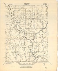 1925 Hoopa1925 Print · USGSNorthwestern California in the mid-twenties centers on the vital corridors of the Klamath River and the Hoopa Valley Indian Reservation. Genealogists and historians can trace riverside settlements and landmarks like Martins Ferry, Weitchpec, and Orleans.
 - 1945 Map of Tectah Creek
 1945 Tectah Creek1945 Print · USGSThe Klamath River corridor comes to life in the mid-1940s, showing a network of remote riverside settlements and upland prairies. Genealogists and researchers can locate family-named sites like McCOVEY RANCH and historic community hubs like Pecwan-Union School.
 - 1948 Map of Weed, 1950 Print
 1948 Weed1950 Print · USGSNorthern California and Southern Oregon are captured here during the post-war era, documenting the mountain-and-valley economies of the Klamath and Cascade ranges. Trace the legacy of local mining and timber at the King Solomon Mine, find old schools like Siskiyou County School, and follow the historic Southern Pacific RR route.2 unique versions available
 - 1950 Map of Weed
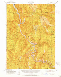
 1950 Weed1950 Print · USGSSiskiyou County and the surrounding Klamath mountains appear in the mid-century before extensive modern development. Genealogists and local historians can locate remote outposts like the Lee Brown Ranch and the specialized settlement of Darlingtonia.
 - 1952 Map of Tectah Creek, 1954 Print
 1952 Tectah Creek1954 Print · USGSThe Klamath River corridor in the early fifties shows a landscape of river-dependent settlements and isolated mountain ranches. Genealogists and researchers can locate Mc Covey Ranch, the Pecwan Union School, and riverside points like Johnsons.3 unique versions available
 - 1958 Map of Weed, 1963 Print
 1958 Weed1963 Print · USGSThe Northern California high country of the late fifties is defined by the towering presence of Mt Shasta and the logging railroads of the Siskiyou range. Genealogists and researchers can trace remote mining sites like the China Mine and mountain settlements such as Sawyers Bar and Seiad Valley.3 unique versions available
 - 1963 Map of Weed
 1963 Weed1963 Print · USGSNorthern California during the early 1960s shows a landscape of steep mountain ranges and river-fed valleys at the height of the timber era. Researchers can trace the routes of the McCloud River RR, locate remote sites like the Holiday Mine, or find ancestral markers at the Scott Valley Cem.
 - 1982 Map of Johnsons, 1983 Print
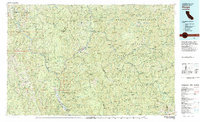
 1982 Johnsons1983 Print · USGSThe Klamath River corridor within the Hoopa Valley Indian Reservation is documented here in the early 1980s. Genealogists and local historians can trace riverfront settlements like Johnsons, Pecwan, and Cappell Flat, alongside the Jack Norton Sch.
 - 1983 Map of Hoopa
 1983 Hoopa1983 Print · USGSThe Klamath and Trinity Rivers converge in the early eighties at Weitchpec, carving through a landscape of national forests and the Hoopa Indian Reservation. Researchers can trace remote settlements like Orleans and Cecilville or locate landmarks like Tish Tang Creek and English Peak.
 - 1997 Map of Johnsons, 2001 Print
 1997 Johnsons2001 Print · USGSThe Klamath River corridor near the turn of the millennium was a landscape of remote river settlements and tribal lands. Genealogists and local historians can trace the foundations of Pecwan, the Jack Norton School, and family landmarks like Moore Ranch.
End of results
Showing maps 1-10 of 10
Frequently asked questions
- What are the different types of historical maps available for Cappell?
- What is the oldest map of Cappell?
- Where can I purchase historical maps of Cappell for my home or office?
- Where can I download high-res historical maps of Cappell?
- Are there historical topographic maps available for Cappell?
- Is there historical aerial imagery available for Cappell?
- Where are historical maps of Cappell sourced from?