1950s Maps of Brawley, California
Explore 9 historic maps of Brawley from the 1950s. These maps offer a rare glimpse into what life looked like during the 1950s — showing old roads, neighborhoods, homes, and landmarks that have changed or disappeared over time.
Whether you're researching your family's past, planning a metal detecting trip, or studying how Brawley's landscape evolved across the 1950s, these high-resolution maps are a powerful tool for exploring the history of this region.
- Focus on a specific era: All maps on this page are from the 1950s, giving you a focused view of this time period.
- See what’s changed: Compare century-old streets, trails, and buildings to today's modern landscape using overlays and satellite layers.
- Research with precision: Use these maps for genealogy, historical research, land use analysis, or educational projects.
- View, download, or print: Maps are fully viewable online in high resolution, and can be downloaded or printed for your own records.
Start exploring Brawley's history through authentic maps from the 1950s. This is your window into the past.
Brawley, CA maps
(9)- 1954 Map of El Centro
 1954 El Centro1954 Print · USGSThe Imperial Valley was at its mid-century agricultural peak when this survey recorded its vast irrigation network and desert borderlands. Researchers can trace the path of the All American Canal or locate local landmarks like Lantana School and the Tumco Mines.
 - 1954 Map of Salton Sea
 1954 Salton Sea1954 Print · USGSThe Colorado River and Imperial Valley desert frontiers are captured here in the 1950s. Trace the irrigation networks of Calipatria and mining sites like Eagle Mountain Mine.
 - 1955 Map of Salton Sea
 1955 Salton Sea1955 Print · USGSThe Colorado River and Imperial Valley desert basins appear here during the mid-fifties, revealing a landscape of remote mines and agricultural irrigation. Genealogists and researchers can trace locations like the Parker Alien Reception Center Unit No 1, Blythe, and the Kane Springs School.2 unique versions available
 - 1955 Map of El Centro
 1955 El Centro1955 Print · USGSThe Imperial Valley and the Colorado River borderlands are captured here in the mid-fifties during the peak of the region's irrigation-driven expansion. Researchers can trace the desert's industrial history through the Tumco Mines, the Yuma Test Branch, and rural landmarks like the Palmetto School.
 - 1956 Map of Westmorland, 1957 Print
 1956 Westmorland1957 Print · USGSImperial Valley's agricultural heartland is captured here in the mid-1950s, showing the intricate irrigation systems and rail-dependent towns of the California desert. Researchers can trace the early layout of Westmorland and Calipatria, alongside remote stations like Rockwood and the riparian habitats of Ramer Lake.3 unique versions available
 - 1957 Map of Brawley, 1958 Print
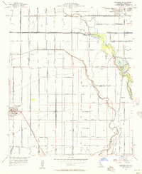
 1957 Brawley1958 Print · USGSBrawley and the Imperial Valley are captured here in the late fifties, showcasing a complex landscape of desert agriculture and industrial growth. Researchers can trace local roots through numerous landmarks like Union HS, the SUGAR REFINERY, and Riverview Cemetery.4 unique versions available
 - 1957 Map of Brawley, 1961 Print
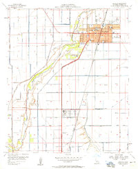
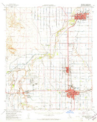 1957 Brawley1961 Print · USGSThe Imperial Valley's agricultural heartland thrived in the late fifties through an immense network of irrigation and rail. Genealogists and local historians can trace family roots through numerous local schools like Oakley Sch and burial sites including Memory Gardens Cem and Imperial Cem.
 - 1958 Map of El Centro, 1972 Print
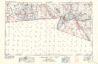 1958 El Centro1972 Print · USGSThe Imperial Valley's agricultural heartland and the Colorado River's edge are captured here during a period of massive water infrastructure and military expansion. Genealogists and historians can trace old mining sites like the Ferguson Mine, desert outposts such as Ogilby, and early rail lines including the San Diego and Arizona Eastern.4 unique versions available
 - 1959 Map of Salton Sea, 1968 Print
 1959 Salton Sea1968 Print · USGSThe Colorado River and Salton Sea basin are shown here during a decade of intense military and agricultural activity. Trace family roots in Blythe or Niland, and locate historical mining operations like the Eagle Mountain Mine and Red Cloud Mine.4 unique versions available
End of results
Showing maps 1-9 of 9
Top cities near Brawley
- El Centro historical maps
- Imperial historical maps
- Calipatria historical maps
- Holtville historical maps
- Westmorland historical maps
- Poe Colonia historical maps
Frequently asked questions
- What are the different types of historical maps available for Brawley?
- What is the oldest map of Brawley?
- Where can I purchase historical maps of Brawley for my home or office?
- Where can I download high-res historical maps of Brawley?
- Are there historical topographic maps available for Brawley?
- Is there historical aerial imagery available for Brawley?
- Where are historical maps of Brawley sourced from?