1980s Maps of Alico, California
Explore 2 historic maps of Alico from the 1980s. These maps offer a rare glimpse into what life looked like during the 1980s — showing old roads, neighborhoods, homes, and landmarks that have changed or disappeared over time.
Whether you're researching your family's past, planning a metal detecting trip, or studying how Alico's landscape evolved across the 1980s, these high-resolution maps are a powerful tool for exploring the history of this region.
- Focus on a specific era: All maps on this page are from the 1980s, giving you a focused view of this time period.
- See what’s changed: Compare century-old streets, trails, and buildings to today's modern landscape using overlays and satellite layers.
- Research with precision: Use these maps for genealogy, historical research, land use analysis, or educational projects.
- View, download, or print: Maps are fully viewable online in high resolution, and can be downloaded or printed for your own records.
Start exploring Alico's history through authentic maps from the 1980s. This is your window into the past.
Alico, CA maps
(2)- 1985 Map of Saline Valley
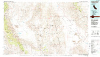 1985 Saline Valley1985 Print · USGSInyo County during the mid-1980s reveals a desert landscape of remote mining claims and isolated outposts between the high ranges. Geologists and researchers can trace the roads to Teakettle Junction or locate the historic Cerro Gordo Mine and Stovepipe Wells.2 unique versions available
 - 1987 Map of Dolomite
 1987 Dolomite1987 Print · USGSThe eastern shore of Owens Lake in the late 1980s reveals a landscape shaped by mining and water management. Researchers can trace the industrial heritage of the Inyo Mountains through the Old R.R. Grade, the ruins at Swansea, and the Dolomite settlement.3 unique versions available
End of results
Showing maps 1-2 of 2
Top cities near Alico
Frequently asked questions
- What are the different types of historical maps available for Alico?
- What is the oldest map of Alico?
- Where can I purchase historical maps of Alico for my home or office?
- Where can I download high-res historical maps of Alico?
- Are there historical topographic maps available for Alico?
- Is there historical aerial imagery available for Alico?
- Where are historical maps of Alico sourced from?