1980s Maps of Indian Village, California
Explore 3 historic maps of Indian Village from the 1980s. These maps offer a rare glimpse into what life looked like during the 1980s — showing old roads, neighborhoods, homes, and landmarks that have changed or disappeared over time.
Whether you're researching your family's past, planning a metal detecting trip, or studying how Indian Village's landscape evolved across the 1980s, these high-resolution maps are a powerful tool for exploring the history of this region.
- Focus on a specific era: All maps on this page are from the 1980s, giving you a focused view of this time period.
- See what’s changed: Compare century-old streets, trails, and buildings to today's modern landscape using overlays and satellite layers.
- Research with precision: Use these maps for genealogy, historical research, land use analysis, or educational projects.
- View, download, or print: Maps are fully viewable online in high resolution, and can be downloaded or printed for your own records.
Start exploring Indian Village's history through authentic maps from the 1980s. This is your window into the past.
Indian Village, CA maps
(3)- 1986 Map of Death Valley Junction
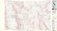 1986 Death Valley Junction1986 Print · USGSThe California-Nevada borderlands appear here in the mid-eighties, centered on the dramatic terrain of the Death Valley National Monument. Researchers can trace the path of the Tonopah and Tidewater Railroad (Abandoned) and locate remote outposts like Ryan and Bennetts Well.2 unique versions available
 - 1988 Map of Furnace Creek
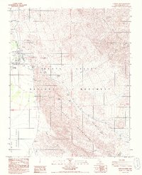 1988 Furnace Creek1988 Print · USGSInyo County’s high-desert history is detailed in the late eighties as tourism and legacy mining sites intersect. Researchers can trace the layout of the Indian Village, locate a historical Cem, and explore the grounds of the Harmony Borax Works (Ruins).2 unique versions available
 - 1988 Map of West of Furnace Creek
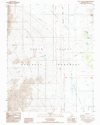 1988 West of Furnace Creek1988 Print · USGSDeath Valley in the late eighties presents a stark study of desert hydrology and high-relief topography. Researchers can trace the drainage of Blackwater Wash from the heights of Tucki Mountain down toward the Devils Golf Course and Death Valley Airport.
End of results
Showing maps 1-3 of 3
Frequently asked questions
- What are the different types of historical maps available for Indian Village?
- What is the oldest map of Indian Village?
- Where can I purchase historical maps of Indian Village for my home or office?
- Where can I download high-res historical maps of Indian Village?
- Are there historical topographic maps available for Indian Village?
- Is there historical aerial imagery available for Indian Village?
- Where are historical maps of Indian Village sourced from?