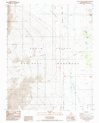
1988 Map of West of Furnace Creek
USGS Topo · Published 1988About this map
Death Valley National Monument reveals a landscape of extreme elevation changes and hydraulic patterns within Cottonball Basin and Middle Basin. The eastern half of the map is dominated by the low-lying Salt Flat, where Salt Creek and Middle Creek flow through the arid valley floor toward the Devils Golf Course. To the west, the terrain rises sharply into the rugged slopes of Tucki Mountain, which is dissected by large drainage features like Tucki Wash and Blackwater Wash. Small-scale modern infrastructure is present on the valley floor, including the Death Valley Airport and several Sewage Disposal Ponds near the northern boundary. The grid of the San Bernardino Meridian provides a surveying framework for this wilderness area, while a singular Transmission Line cuts across the northern alluvial fans.
Find a feature on this map
15 named features on this map. Tap any name to fly to it.
Don’t see what you’re looking for? This feature index may not catch every label — zoom into the map to look around manually.
Map Details
Editions of this 1988 West of Furnace Creek Map
This is the sole edition of this map. No revisions or reprints were ever made.
Other maps of this area

1908 · Furnace Creek
USGS Topo · 1:250,000

1908 · Ballarat
USGS Topo · 1:250,000

1910 · Furnace Creek
USGS Topo · 1:250,000

1913 · Ballarat
USGS Topo · 1:250,000

1942 · Bullfrog
USGS Topo · 1:125,000

1948 · Death Valley
USGS Topo · 1:250,000

1952 · Chloride Cliff
USGS Topo · 1:50,000

1952 · Stovepipe Wells
USGS Topo · 1:62,500

1952 · Furnace Creek
USGS Topo · 1:62,500

1952 · Emigrant Canyon
USGS Topo · 1:62,500