1970s Maps of Baker, Boron
Explore 2 historic maps of Baker from the 1970s. These maps offer a rare glimpse into what life looked like during the 1970s — showing old roads, neighborhoods, homes, and landmarks that have changed or disappeared over time.
Whether you're researching your family's past, planning a metal detecting trip, or studying how Baker's landscape evolved across the 1970s, these high-resolution maps are a powerful tool for exploring the history of this region.
- Focus on a specific era: All maps on this page are from the 1970s, giving you a focused view of this time period.
- See what’s changed: Compare century-old streets, trails, and buildings to today's modern landscape using overlays and satellite layers.
- Research with precision: Use these maps for genealogy, historical research, land use analysis, or educational projects.
- View, download, or print: Maps are fully viewable online in high resolution, and can be downloaded or printed for your own records.
Start exploring Baker's history through authentic maps from the 1970s. This is your window into the past.
Baker, Boron maps
(2)- 1973 Map of Boron, 1976 Print
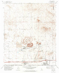 1973 Boron1976 Print · USGSBoron and the surrounding Mojave landscape appear here in the early seventies during a period of intense mineral production. Researchers can trace the massive Open Pit Mine and local infrastructure like West Boron Sch and the historic 20 Mule Team Road.2 unique versions available
 - 1976 Map of Cuddeback Lake, 1993 Print
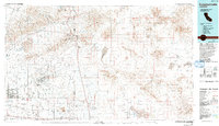 1976 Cuddeback Lake1993 Print · USGSThe western Mojave Desert comes into focus in the mid-seventies, showing the intersection of historic mining districts and modern aerospace facilities. You can trace the workings of the Yellow Aster Mine, the streets of California City, and the path of the Los Angeles Aqueduct.
End of results
Showing maps 1-2 of 2
Top cities near Baker
Frequently asked questions
- What are the different types of historical maps available for Baker?
- What is the oldest map of Baker?
- Where can I purchase historical maps of Baker for my home or office?
- Where can I download high-res historical maps of Baker?
- Are there historical topographic maps available for Baker?
- Is there historical aerial imagery available for Baker?
- Where are historical maps of Baker sourced from?