1980s Maps of Mirasol Ranch, California
Explore 1 historic maps of Mirasol Ranch from the 1980s. These maps offer a rare glimpse into what life looked like during the 1980s — showing old roads, neighborhoods, homes, and landmarks that have changed or disappeared over time.
Whether you're researching your family's past, planning a metal detecting trip, or studying how Mirasol Ranch's landscape evolved across the 1980s, these high-resolution maps are a powerful tool for exploring the history of this region.
- Focus on a specific era: All maps on this page are from the 1980s, giving you a focused view of this time period.
- See what’s changed: Compare century-old streets, trails, and buildings to today's modern landscape using overlays and satellite layers.
- Research with precision: Use these maps for genealogy, historical research, land use analysis, or educational projects.
- View, download, or print: Maps are fully viewable online in high resolution, and can be downloaded or printed for your own records.
Start exploring Mirasol Ranch's history through authentic maps from the 1980s. This is your window into the past.
Mirasol Ranch, CA maps
(1)- 1981 Map of Taft, 1982 Print
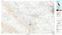 1981 Taft1982 Print · USGSKern County's oil country and the high desert of the San Luis Obispo border come into focus during the early eighties. Researchers can trace the industrial landscape of Naval Petroleum Reserve No 1 alongside settlements like Taft, McKittrick, and the San Andreas Rift Zone.2 unique versions available
End of results
Showing maps 1-1 of 1
Top cities near Mirasol Ranch
- Bakersfield historical maps
- Wasco historical maps
- Shafter historical maps
- Taft historical maps
- Buttonwillow historical maps
Frequently asked questions
- What are the different types of historical maps available for Mirasol Ranch?
- What is the oldest map of Mirasol Ranch?
- Where can I purchase historical maps of Mirasol Ranch for my home or office?
- Where can I download high-res historical maps of Mirasol Ranch?
- Are there historical topographic maps available for Mirasol Ranch?
- Is there historical aerial imagery available for Mirasol Ranch?
- Where are historical maps of Mirasol Ranch sourced from?