Old Maps of Bakersfield, California
Explore 87 old maps of Bakersfield, spanning from 1906 to today. These high-resolution historic maps reveal how streets, neighborhoods, landmarks, and natural features evolved over time — perfect for genealogy, metal detecting, research, and local history exploration.
What you can do with these maps:
- See how Bakersfield changed over time: Compare historical maps to modern-day views to trace roads, homesites, rail lines & more.
- View detailed metadata: Each map includes creators, publishers, year, scale, and archive source.
- Overlay maps with satellite & LiDAR: Visualize the past alongside modern tools to explore terrain & human change.
- Trusted historical sources: Maps sourced from the USGS, Library of Congress, and other archives.
- Access maps your way: View online, download high-res files, or order prints for personal or research use.
Start exploring old maps of Bakersfield to uncover forgotten places, hidden landmarks, and the deep history beneath your feet.
Bakersfield, CA maps
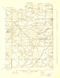
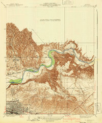
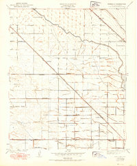
(87)- 1906 Map of Bakersfield
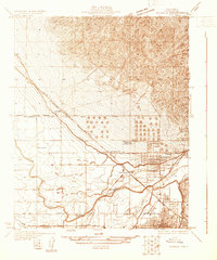
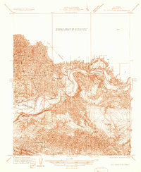
 1906 Bakersfield1906 Print · USGSIn the early 1900s, Bakersfield was the heart of a booming oil and rail network just as the landscape was being transformed. Genealogists and historians can trace early settlements like Oil Center and Jewetta or the industrial workings of the Fullers Earth Mine.5 unique versions available
 - 1910 Map of Buena Vista Lake, 1912 Print
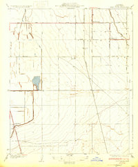
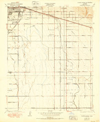
 1910 Buena Vista Lake1912 Print · USGSThe southern San Joaquin Valley comes to life in the years before the great lakes were drained for agriculture. Genealogists and historians can trace early rail stops like Bowerbank and Hazelton or locate rural landmarks such as the Palm School and Moron Taft P O.
 - 1912 Map of Buena Vista Lake, 1921 Print
 1912 Buena Vista Lake1921 Print · USGSThe San Joaquin Valley at the height of its irrigation and oil boom is captured here, from the streets of Bakersfield to the shores of Buena Vista Lake. Genealogists and local historians can trace early schools like Old River School and the rail stops of the Sunset RR.4 unique versions available
 - 1914 Map of Caliente
 1914 Caliente1914 Print · USGSBakersfield and the southern Joaquin Valley are captured in the early nineteen-teens as the region's rail and oil industries expanded. Genealogists can trace family landmarks like the Tejon Ranch and Rio Bravo Ranch or locate vanished stops such as Woodford Keene P O and Cottonwood Station.7 unique versions available
 - 1929 Map of Stevens
 1929 Stevens1929 Print · USGSThe Kern River valley in the late 1920s was a hub of early irrigation and oil development. Researchers can trace the legacy of local education and industry through sites like Munzer Sch, the Elmer Oil Company, and the Rio Bravo Oil Pumping Station.
 - 1929 Map of Fairfax School
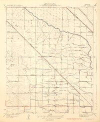
 1929 Fairfax School1929 Print · USGSSoutheastern Bakersfield and the surrounding Kern County ranch lands are captured here in the late twenties, during a period of significant agricultural growth. Genealogists and local historians can trace rural school districts like Fairfax Sch and Mountain View Sch alongside the essential Kern Island Canal system.
 - 1929 Map of Coles Levee
 1929 Coles Levee1929 Print · USGSKern County in the late twenties shows a landscape defined by water engineering and early transport. You can trace the Southern Pacific RR and find sites like the Mesquite Hunting Club and the Western Water Co Pumping Plant.
 - 1930 Map of Weed Patch
 1930 Weed Patch1930 Print · USGSKern County farmland was rapidly expanding in the 1930s as irrigation networks transformed the valley floor. Genealogists and historians can trace the early layout of Weed Patch and the Vineland Sch along with the path of the Southern Pacific Railroad.
 - 1930 Map of Rosedale
 1930 Rosedale1930 Print · USGSRosedale and the surrounding Kern County landscape appear here in the early thirties as a thriving agricultural and rail-oriented community. Researchers can locate the White Church, Palm Sch, and transit points like Rosedale Sta or Una Siding.
 - 1930 Map of Oildale
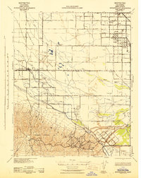
 1930 Oildale1930 Print · USGSThe northern reaches of the Central Valley come alive in the early 1930s as petroleum and aviation take root. Researchers can trace the early layout of Oildale alongside the Kern County Airplane Landing Field and rural schools like Beardsley Sch.
 - 1932 Map of Stevens
 1932 Stevens1932 Print · USGSCentral California's agricultural and oil-producing heartland comes into focus in the early 1930s near the Kern River. Family historians can trace the locations of the Munzer Sch and Buena Vista Sch alongside the tracks of the Southern Pacific.3 unique versions available
 - 1932 Map of Fairfax School
 1932 Fairfax School1932 Print · USGSKern County's agricultural heartland south of Bakersfield is captured here in the early 1930s as irrigation and railroads fueled the valley's growth. Genealogists and local historians can trace the foundations of Lamont or locate rural landmarks like Fairfax School and the Kern Island Canal.3 unique versions available
 - 1932 Map of Gosford
 1932 Gosford1932 Print · USGSBakersfield and the southern Kern County plains are seen here during the early 1930s as irrigation transformed the valley floor. Genealogists can locate family landmarks along Stine Road, early education at Fairview Sch, and the rural hub of Gosford.3 unique versions available
 - 1933 Map of Tupman
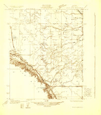
 1933 Tupman1933 Print · USGSThe oil fields of Kern County come alive in this early 1930s survey, showing the peak of industrial settlement in the Elk Hills. Genealogists can locate specific worker housing at the Standard Oil Co Camp or trace the early course of the Buena Vista Slough.3 unique versions available
 - 1933 Map of Oil Center
 1933 Oil Center1933 Print · USGSKern County's petroleum industry is in full swing during the early 1930s as the Kern River Oil Field transforms the terrain north of Bakersfield. Researchers can trace early company towns and oil-related infrastructure like the Oil Center (P.O.), Petroleum Sch, and the Southern Pacific line.
 - 1933 Map of Weed Patch
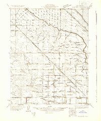
 1933 Weed Patch1933 Print · USGSKern County farmland in the early 1930s is revealed here as a landscape of precision irrigation and new highways. Researchers can trace family-named sites and rural infrastructure like Vineland Sch, Teel Ranch, and the Adobe Canal.3 unique versions available
 - 1933 Map of Rosedale
 1933 Rosedale1933 Print · USGSKern County's irrigation and rail networks are in full view in this early 1930s survey of the Rosedale area. Genealogists can locate family-named landmarks and essential rural institutions like Palm Sch, the White Ch, and the stop at Una Siding.3 unique versions available
 - 1935 Map of Oildale
 1935 Oildale1935 Print · USGSThe San Joaquin Valley landscape north of Bakersfield comes alive in this mid-1930s survey of oil fields and irrigation. Genealogists and historians can trace local life through Standard Sch, the growing streets of Oildale, and the early Kern County Landing Field.3 unique versions available
 - 1940 Map of Oil Center
 1940 Oil Center1940 Print · USGSBakersfield and its surrounding oil fields are caught here at a moment of intense industrial development during the late thirties and early fourties. Genealogists and researchers can trace local landmarks like Oil Center, the County Hospital, and several rural schools including Petroleum Sch.2 unique versions available
 - 1942 Map of Buttonwillow
 1942 Buttonwillow1942 Print · USGSKern County's agricultural and energy heartland is meticulously detailed in this wartime survey of the San Joaquin Valley. Researchers can trace family ranch boundaries like Woolner Ranch, locate the Rio Bravo Oil Field, and follow the Southern Pacific McKittrick Branch rail line.
 - 1942 Map of Bakersfield West, 1944 Print
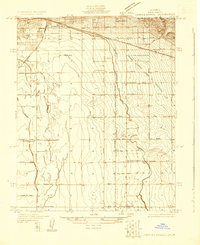
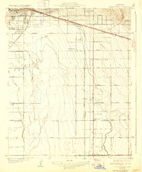
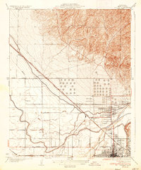
 1942 Bakersfield West1944 Print · USGSBakersfield and the surrounding oil fields are shown here during the early war years, revealing a landscape defined by petroleum and irrigation. Genealogists can locate family holdings near Rosedale, Pumpkin Center, or early schoolhouses like Greeley Sch.
 - 1948 Map of Bakersfield
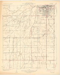
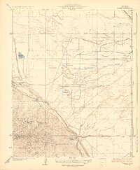
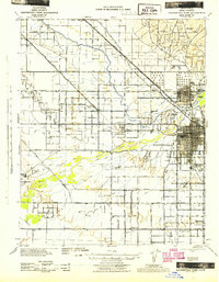
 1948 Bakersfield1948 Print · USGSBakersfield and the southern San Joaquin Valley appear in the late 1940s, showing a landscape of burgeoning oil towns, rail junctions, and early irrigation canals. Genealogists and historians can trace the foundations of local industry through Gardner Field, the Sunset Railway, and the shores of Buena Vista Lake.2 unique versions available
 - 1950 Map of Gosford
 1950 Gosford1950 Print · USGSSouthwest Bakersfield and the surrounding Kern County ranch lands are caught in a moment of post-war expansion. Local researchers can trace the historic irrigation network of the Stine Canal and find old rural schools like Union Ave Sch and Fairview Sch.
 - 1950 Map of Rosedale
 1950 Rosedale1950 Print · USGSThe Rosedale area of Kern County is shown during a period of significant agricultural expansion and rail development. Researchers can trace early irrigation networks like the Calloway Canal and locate vanished local landmarks such as Una Siding and Palm Sch.
 - 1950 Map of Fairfax School
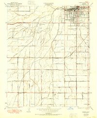
 1950 Fairfax School1950 Print · USGSThe outskirts of Bakersfield and the surrounding Kern County farmland are captured here at the start of the 1950s. Genealogists and local historians can trace irrigation networks like the Weed Patch Canal and locate rural landmarks such as Fairfax School and the rail hub at Magunden.
Showing maps 1-25 of 87
Top cities near Bakersfield
Top neighborhoods of Bakersfield
- Quailwood historical maps
- Kern historical maps
- Wible Orchard historical maps
- Kern City historical maps
- The Polo Greens historical maps
Frequently asked questions
- What are the different types of historical maps available for Bakersfield?
- What is the oldest map of Bakersfield?
- Where can I purchase historical maps of Bakersfield for my home or office?
- Where can I download high-res historical maps of Bakersfield?
- Are there historical topographic maps available for Bakersfield?
- Is there historical aerial imagery available for Bakersfield?
- Where are historical maps of Bakersfield sourced from?