1940s Maps of Tehachapi, California
Explore 3 historic maps of Tehachapi from the 1940s. These maps offer a rare glimpse into what life looked like during the 1940s — showing old roads, neighborhoods, homes, and landmarks that have changed or disappeared over time.
Whether you're researching your family's past, planning a metal detecting trip, or studying how Tehachapi's landscape evolved across the 1940s, these high-resolution maps are a powerful tool for exploring the history of this region.
- Focus on a specific era: All maps on this page are from the 1940s, giving you a focused view of this time period.
- See what’s changed: Compare century-old streets, trails, and buildings to today's modern landscape using overlays and satellite layers.
- Research with precision: Use these maps for genealogy, historical research, land use analysis, or educational projects.
- View, download, or print: Maps are fully viewable online in high resolution, and can be downloaded or printed for your own records.
Start exploring Tehachapi's history through authentic maps from the 1940s. This is your window into the past.
Tehachapi, CA maps
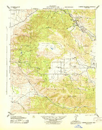
(3)- 1943 Map of Tehachapi
 1943 Tehachapi1943 Print · USGSTehachapi and the surrounding mountain passes are captured in the early 1940s during a period of vital rail and industrial activity. Trace the SOUTHERN PACIFIC line through the Tehachapi Pass or locate rural sites like Jameson Ranch and the Pine Tree Mine.4 unique versions available
 - 1943 Map of Cummings Mountain
 1943 Cummings Mountain1943 Print · USGSThe Southern Pacific railroad traverses the Tehachapi Mountains during the mid-forties, carving through steep canyons and mountain passes. Researchers can trace the rail line through Walong or locate local landmarks like the Keene PO, Stonybrook Retreat, and Cummings Valley School.5 unique versions available
 - 1948 Map of Bakersfield
 1948 Bakersfield1948 Print · USGSBakersfield and the southern San Joaquin Valley appear in the late 1940s, showing a landscape of burgeoning oil towns, rail junctions, and early irrigation canals. Genealogists and historians can trace the foundations of local industry through Gardner Field, the Sunset Railway, and the shores of Buena Vista Lake.2 unique versions available
End of results
Showing maps 1-3 of 3
Top cities near Tehachapi
Frequently asked questions
- What are the different types of historical maps available for Tehachapi?
- What is the oldest map of Tehachapi?
- Where can I purchase historical maps of Tehachapi for my home or office?
- Where can I download high-res historical maps of Tehachapi?
- Are there historical topographic maps available for Tehachapi?
- Is there historical aerial imagery available for Tehachapi?
- Where are historical maps of Tehachapi sourced from?