1900s (20th Century) Maps of Lasco, California
Explore 9 historic maps of Lasco from the 1900s (20th Century). These maps offer a rare glimpse into what life looked like during the 1900s — showing old roads, neighborhoods, homes, and landmarks that have changed or disappeared over time.
Whether you're researching your family's past, planning a metal detecting trip, or studying how Lasco's landscape evolved across the 1900s, these high-resolution maps are a powerful tool for exploring the history of this region.
- Focus on a specific era: All maps on this page are from the 1900s, giving you a focused view of this time period.
- See what’s changed: Compare century-old streets, trails, and buildings to today's modern landscape using overlays and satellite layers.
- Research with precision: Use these maps for genealogy, historical research, land use analysis, or educational projects.
- View, download, or print: Maps are fully viewable online in high resolution, and can be downloaded or printed for your own records.
Start exploring Lasco's history through authentic maps from the 1900s. This is your window into the past.
Lasco, CA maps
(9)- 1955 Map of Westwood, 1957 Print
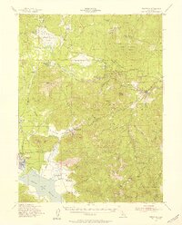 1955 Westwood1957 Print · USGSThe timber and ranching culture of the Lassen highlands is captured here during the mid-fifties. Genealogists and historians can trace family properties like Worley Ranch and Stephens Ranch or follow the rails to Westwood Junction.3 unique versions available
 - 1955 Map of Westwood, 1959 Print
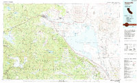
 1955 Westwood1959 Print · USGSIn the mid-fifties, the northeastern California interior supported a landscape of mountain timber and high-desert basins. Genealogists and historians can locate early settlements and industrial sites like Susanville, Herlong, and the Sierra Ordinance Depot.
 - 1958 Map of Westwood
 1958 Westwood1958 Print · USGSNorthern California in the late fifties shows a landscape of volcanic peaks and rising reservoirs. Researchers can locate the Sierra Ordinance Depot and trace mountain infrastructure through the Hat Creek Ranger Station and Stacy Siding.
 - 1959 Map of Westwood
 1959 Westwood1959 Print · USGSNortheastern California during the late 1950s was a hub of timber, military logistics, and mountain railroading. Researchers can trace the path of the Southern Pacific through the Honey Lake Valley and locate landmarks like the Sierra Ordinance Depot and Lassen Peak.
 - 1962 Map of Susanville, 1965 Print
 1962 Susanville1965 Print · USGSNortheastern California's high desert and volcanic peaks meet in the early sixties, showing the region's timber and rail hubs in transition. Local historians can trace the Southern Pacific lines through Susanville and Litchfield, or explore the sprawling Sierra Army Depot and Lassen Volcanic National Park.2 unique versions available
 - 1968 Map of Susanville
 1968 Susanville1968 Print · USGSThe high Sierras and the Great Basin collide in the late 1960s, showing a landscape of volcanic peaks, timber settlements, and desert plains. Genealogists and researchers can trace historic rail lines like the Western Pacific or locate residents in Susanville, Westwood, and Janesville.
 - 1980 Map of Pegleg Mountain
 1980 Pegleg Mountain1980 Print · USGSHigh in the Lassen National Forest during the late twentieth century, this terrain reveals the vital intersection of water storage and mountain transit. Trace the rail heritage of the Western Pacific and Westwood Junction alongside Pegleg Mtn.
 - 1984 Map of Susanville
 1984 Susanville1984 Print · USGSLassen and Plumas counties in the mid-1980s showcase a high-altitude landscape of timber, military installations, and valley settlements. Genealogists and local historians can trace the rail corridors of the Southern Pacific and Western Pacific near Susanville or locate smaller locales like Crescent Mills and the Sierra Army Depot.2 unique versions available
 - 1995 Map of Pegleg Mountain, 1997 Print
 1995 Pegleg Mountain1997 Print · USGSLassen National Forest was a hub of timber transport and water management in the 1990s. Trace the path of the Bizz Johnson Trail and the Old Railroad Grade past Mc Coy Flat Reservoir and the Lookout on Pegleg Mountain.
End of results
Showing maps 1-9 of 9
Top cities near Lasco
Frequently asked questions
- What are the different types of historical maps available for Lasco?
- What is the oldest map of Lasco?
- Where can I purchase historical maps of Lasco for my home or office?
- Where can I download high-res historical maps of Lasco?
- Are there historical topographic maps available for Lasco?
- Is there historical aerial imagery available for Lasco?
- Where are historical maps of Lasco sourced from?