Old Maps of Lassen County, California
Explore 727 old maps of Lassen County, spanning from 1886 to today. These high-resolution historic maps reveal how streets, neighborhoods, landmarks, and natural features evolved over time — perfect for genealogy, metal detecting, research, and local history exploration.
What you can do with these maps:
- See how Lassen County changed over time: Compare historical maps to modern-day views to trace roads, homesites, rail lines & more.
- View detailed metadata: Each map includes creators, publishers, year, scale, and archive source.
- Overlay maps with satellite & LiDAR: Visualize the past alongside modern tools to explore terrain & human change.
- Trusted historical sources: Maps sourced from the USGS, Library of Congress, and other archives.
- Access maps your way: View online, download high-res files, or order prints for personal or research use.
Start exploring old maps of Lassen County to uncover forgotten places, hidden landmarks, and the deep history beneath your feet.
Lassen County, CA maps
(727)- 1886 Map of Alturas
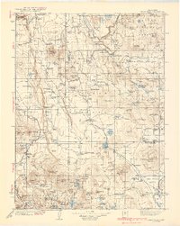
 1886 Alturas1886 Print · USGSNortheastern California at the close of the nineteenth century was a territory of high-desert basins and isolated outposts. Researchers can trace early township developments and strategic sites like Fort Bidwell, the remote Old Indian Villages, and the mining camp at Hayden Hill.
 - 1886 Map of Honey Lake
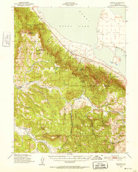
 1886 Honey Lake1886 Print · USGSLassen and Plumas counties were a frontier of ranching and early commerce in the late nineteenth century. Genealogists can locate family-named settlements like Stocktons and Taylorsville or trace the early water rights near Susanville and Honey Lake.
 - 1886 Map of Lassen Peak
 1886 Lassen Peak1886 Print · USGSThe Cascades of the late nineteenth century appear here as a landscape of timber mills and volcanic peaks. Genealogists and historians can trace early mountain life at Shingletown, Prattville, and isolated industrial sites like Eureka Mill or the Caribou Bridge.
 - 1886 Map of Modoc Lava Bed
 1886 Modoc Lava Bed1886 Print · USGSNortheastern California is surveyed here in the years following the Modoc War, showing the volcanic terrain of the Modoc Lava Bed and early river settlements. Trace pioneer history through Modoc Rifle Pits, a Ferry on the Pit River, and old outposts like Bieber and Lookout.
 - 1886 Map of Granite Range
 1886 Granite Range1886 Print · USGSNorthwestern Nevada in the late nineteenth century was a frontier of great lakes and dry basins. Researchers can trace early geography from the Salt Works 3830 in the northern flats to water sources like Sheep-head Spring and Hot Springs.
 - 1889 Map of Long Valley
 1889 Long Valley1889 Print · USGSNorthwestern Nevada was a land of high desert springs and remote outposts in the late nineteenth century. Researchers can trace the legacy of early military presence at Camp McGarry or locate crucial water sources like Massacre Lakes and Soldier Meadows.
 - 1890 Map of Sierraville, 1955 Print
 1890 Sierraville1955 Print · USGSThe high Sierra Valley and its frontier timber towns are captured here in the late 1800s. Genealogists and historians can trace early rail lines like the Nevada California and Oregon Railway and locate vanished stops and landmarks such as Etta, Purdy, and the Sulphur Spring.
 - 1891 Map of Honey Lake
 1891 Honey Lake1891 Print · USGSLassen and Plumas counties appear here in the early 1890s, when the region's cattle ranches and mountain towns were first being systematically mapped. Genealogists and local historians can trace early residents through family-named sites like Halls, Buntingville, and Stocktons.
 - 1891 Map of Reno
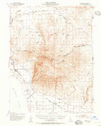
 1891 Reno1891 Print · USGSReno and the high desert valleys of Washoe County were undergoing a rail-driven expansion in the early 1890s. Genealogists and historians can trace early settlements like Poeville and Glendale or follow the path of the Central Pacific Railroad through Truckee Meadows.
 - 1892 Map of Sierraville
 1892 Sierraville1892 Print · USGSSierraville and the high meadows of the eastern Sierras are shown here in the early 1890s, just as the regional rail network was expanding. Genealogists can trace early homesteads and communities like Loyalton, Sattley, and Beckwith, or follow the California Nevada and Oregon Railway as it winds toward the state line.
 - 1892 Map of Modoc Lava-Bed
 1892 Modoc Lava-Bed1892 Print · USGSNortheastern California's volcanic terrain is meticulously charted in the 1890s, before modern irrigation altered the great northern basins. Genealogists and historians can locate early outposts like Burgettville, the Modoc Rifle Pit, and the high-altitude Ice Cave.7 unique versions available
 - 1892 Map of Lassen Peak
 1892 Lassen Peak1892 Print · USGSThe volcanic highlands of the southern Cascades are captured in the late nineteenth century, showing early milling and mountain settlements. Genealogists and historians can trace pioneer sites like Prattville, the old Eureka Mill, and the crossings at Caribou Bridge.
 - 1892 Map of Alturas
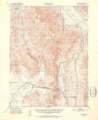
 1892 Alturas1892 Print · USGSNortheastern California at the close of the nineteenth century reveals a landscape of high-desert outposts and military history. Genealogists and historians can trace the early foundations of Fort Bidwell, Cedarville, and the remote Old Indian Villages near the Pit River.7 unique versions available
 - 1893 Map of Honey Lake
 1893 Honey Lake1893 Print · USGSNortheastern California at the close of the 19th century was a landscape of terminal lakes and early valley settlements. Genealogists and historians can trace family-named sites like Moultons and Stocktons, alongside regional hubs like Susanville and the lakeside town of Amedee.6 unique versions available
 - 1893 Map of Reno
 1893 Reno1893 Print · USGSWashoe and Storey counties come to life in the late nineteenth century as Reno emerges as a major railroad hub. Researchers can trace the early paths of the Central Pacific Railroad and locate vanished outposts like Poeville and Junction House.7 unique versions available
 - 1894 Map of Granite Range
 1894 Granite Range1894 Print · USGSNorthwestern Nevada was a landscape of stark basins and vital springs during the late nineteenth century. Researchers can trace the early industrial footprint of the Salt Works 3830 and locate perennial water sources like Sheep-head Spring and Smoke Creek.7 unique versions available
 - 1894 Map of Sierraville
 1894 Sierraville1894 Print · USGSThe high Sierra and Plumas county borderlands are shown in the late nineteenth century as early settlements began to take root in the basin. Researchers can trace the path of the California Nevada and Oregon Railway and locate historic sites like Sierraville, the Fair Grounds, and Loyalton.9 unique versions available
 - 1894 Map of Lassen Peak
 1894 Lassen Peak1894 Print · USGSThe volcanic highlands of Northern California are captured here in the 1890s, shortly after the initial topographic surveys. Genealogists and historians can locate early industry and mountain outposts like Eureka Mill, Prattville, and the remote Hat Creek Post Office.8 unique versions available
 - 1939 Map of Halls Flat
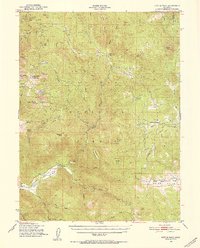
 1939 Halls Flat1939 Print · USGSThe high plateau of eastern Shasta and Lassen counties is shown here in the late 1930s, defined by timber management and remote ranching. Researchers can trace early forest outposts like Halls Flat Ranger Sta, family holdings at DeLashmutt Ranch, and the Western Pacific rail line.3 unique versions available
 - 1950 Map of Chilcoot, 1952 Print
 1950 Chilcoot1952 Print · USGSThe high Sierra gateway at Beckwourth Pass is documented here at mid-century as the railroad and highway networks expanded. Researchers can trace the routes of the Western Pacific and locate local landmarks like Summit Sch and Hallelujah Junction.5 unique versions available
 - 1950 Map of Kettle Rock, 1952 Print
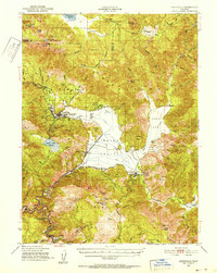
 1950 Kettle Rock1952 Print · USGSThe Plumas National Forest and Diamond Mountains are captured here at the start of the 1950s during a peak era for timber and mining. Researchers can trace the Logging Railroad to Clover Valley Lumber Camp No 14 or locate the remote Engel Mine Upper Camp and Beardsley Mine.3 unique versions available
 - 1950 Map of Greenville, 1952 Print
 1950 Greenville1952 Print · USGSPlumas County at the mid-century shows a landscape shaped by the Western Pacific RR and deep-vein mining operations. Local researchers can trace the footings of the Engel Mine, the Indian Mission, and historical settlements like Crescent Mills and Taylorsville.4 unique versions available
 - 1950 Map of Milford, 1952 Print
 1950 Milford1952 Print · USGSThe high desert basin meets the timbered peaks of the Sierras in the early fifties. Genealogists and historians can trace family-named sites like Clark Ranch, the early operations of the Honey Lake Mine, and the mid-century boundaries of the Dixie Mountain State Game Refuge.3 unique versions available
 - 1954 Map of Susanville
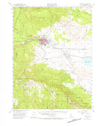 1954 Susanville1954 Print · USGSMid-century Susanville and the surrounding Honey Lake Valley are captured here during a period of steady growth and rail reliance. Researchers can trace family ties at the Lassen Cem, locate Peter Lassens Grave, and see the early layout of the Susanville Indian Rancheria.3 unique versions available
 - 1954 Map of Wendel, 1955 Print
 1954 Wendel1955 Print · USGSLassen County's high desert and military installations come into focus in the mid-1950s. Genealogists and historians can trace the Southern Pacific Railroad through Wendel, locate the Cemetery near Amedee, and find the Pearson Massacre (Site).2 unique versions available
Showing maps 1-25 of 727
Top cities of Lassen County
- Susanville historical maps
- Janesville historical maps
- Westwood historical maps
- Johnstonville historical maps
- Patton Village historical maps
- Doyle historical maps
See more
Frequently asked questions
- What are the different types of historical maps available for Lassen County?
- What is the oldest map of Lassen County?
- Where can I purchase historical maps of Lassen County for my home or office?
- Where can I download high-res historical maps of Lassen County?
- Are there historical topographic maps available for Lassen County?
- Is there historical aerial imagery available for Lassen County?
- Where are historical maps of Lassen County sourced from?