1950s Maps of Lassen County, California
Explore 38 historic maps of Lassen County from the 1950s. These maps offer a rare glimpse into what life looked like during the 1950s — showing old roads, neighborhoods, homes, and landmarks that have changed or disappeared over time.
Whether you're researching your family's past, planning a metal detecting trip, or studying how Lassen County's landscape evolved across the 1950s, these high-resolution maps are a powerful tool for exploring the history of this region.
- Focus on a specific era: All maps on this page are from the 1950s, giving you a focused view of this time period.
- See what’s changed: Compare century-old streets, trails, and buildings to today's modern landscape using overlays and satellite layers.
- Research with precision: Use these maps for genealogy, historical research, land use analysis, or educational projects.
- View, download, or print: Maps are fully viewable online in high resolution, and can be downloaded or printed for your own records.
Start exploring Lassen County's history through authentic maps from the 1950s. This is your window into the past.
Lassen County, CA maps
(38)- 1950 Map of Chilcoot, 1952 Print
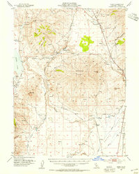
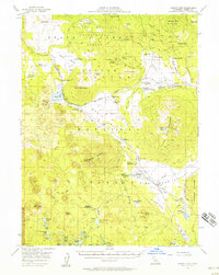
 1950 Chilcoot1952 Print · USGSThe high Sierra gateway at Beckwourth Pass is documented here at mid-century as the railroad and highway networks expanded. Researchers can trace the routes of the Western Pacific and locate local landmarks like Summit Sch and Hallelujah Junction.5 unique versions available
 - 1950 Map of Kettle Rock, 1952 Print
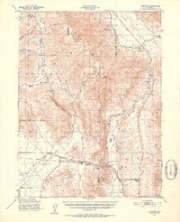
 1950 Kettle Rock1952 Print · USGSThe Plumas National Forest and Diamond Mountains are captured here at the start of the 1950s during a peak era for timber and mining. Researchers can trace the Logging Railroad to Clover Valley Lumber Camp No 14 or locate the remote Engel Mine Upper Camp and Beardsley Mine.3 unique versions available
 - 1950 Map of Greenville, 1952 Print
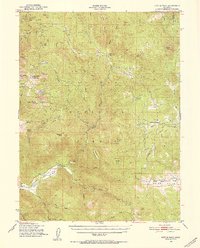
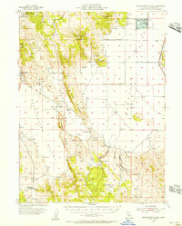
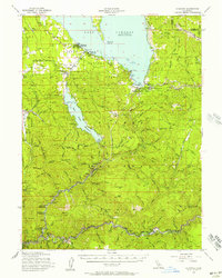
 1950 Greenville1952 Print · USGSPlumas County at the mid-century shows a landscape shaped by the Western Pacific RR and deep-vein mining operations. Local researchers can trace the footings of the Engel Mine, the Indian Mission, and historical settlements like Crescent Mills and Taylorsville.4 unique versions available
 - 1950 Map of Milford, 1952 Print
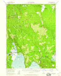
 1950 Milford1952 Print · USGSThe high desert basin meets the timbered peaks of the Sierras in the early fifties. Genealogists and historians can trace family-named sites like Clark Ranch, the early operations of the Honey Lake Mine, and the mid-century boundaries of the Dixie Mountain State Game Refuge.3 unique versions available
 - 1954 Map of Susanville
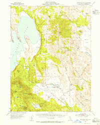
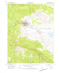 1954 Susanville1954 Print · USGSMid-century Susanville and the surrounding Honey Lake Valley are captured here during a period of steady growth and rail reliance. Researchers can trace family ties at the Lassen Cem, locate Peter Lassens Grave, and see the early layout of the Susanville Indian Rancheria.3 unique versions available
 - 1954 Map of Wendel, 1955 Print
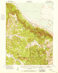
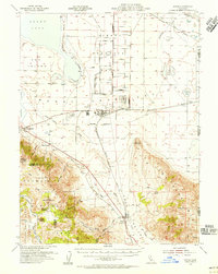
 1954 Wendel1955 Print · USGSLassen County's high desert and military installations come into focus in the mid-1950s. Genealogists and historians can trace the Southern Pacific Railroad through Wendel, locate the Cemetery near Amedee, and find the Pearson Massacre (Site).2 unique versions available
 - 1954 Map of Observation Peak, 1955 Print
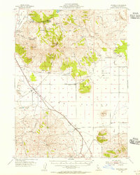
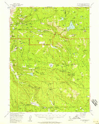
 1954 Observation Peak1955 Print · USGSLassen County ranching and high-desert water management are captured here in the mid-1950s before modern development. Genealogists and historians can trace family-named sites like Horne Ranch, the local Cemetery, and remote outposts such as Rager Res.3 unique versions available
 - 1954 Map of Litchfield, 1955 Print
 1954 Litchfield1955 Print · USGSLassen County's high desert landscape comes alive in the mid-fifties, showing the intersection of ranching and rail as the Southern Pacific spans the valley. Researchers can find old community hubs like Standish and Litchfield, alongside the remote Wendel Hot Springs and Lake School.3 unique versions available
 - 1954 Map of Karlo, 1955 Print
 1954 Karlo1955 Print · USGSLassen County ranching and rail life are preserved here in the mid-1950s. Genealogists and local historians can trace the Southern Pacific tracks through Karlo or locate family-named landmarks like Snowstorm Ranch and Tunison Mtn.2 unique versions available
 - 1954 Map of Grasshopper Valley, 1955 Print
 1954 Grasshopper Valley1955 Print · USGSLassen County ranching and rail infrastructure are captured here in the mid-1950s. Genealogists and local historians can locate the Dry Valley Cemetery, trace the SOUTHERN PACIFIC line, or identify family-named sites like McCoy Flat and Monroe Corrals.3 unique versions available
 - 1954 Map of Doyle, 1956 Print
 1954 Doyle1956 Print · USGSLassen County's high-desert landscape and military infrastructure are detailed here in the mid-fifties. Genealogists and historians can trace the development of Herlong and the Sierra Ordnance Depot alongside rural landmarks like Bird Flat Sch and the Honey Lake Cemetery.3 unique versions available
 - 1954 Map of Ravendale, 1956 Print
 1954 Ravendale1956 Print · USGSHigh desert life in Lassen County comes into focus in the mid-1950s, centered on the railroad stops and working ranches of the Made Line Plains. Trace family history at Ravendale and Termo, or locate early sites like the Butte Sch and the Brockmans Horse Camp.3 unique versions available
 - 1954 Map of Fredonyer Peak, 1956 Print
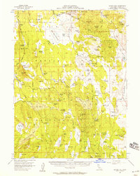
 1954 Fredonyer Peak1956 Print · USGSLassen County ranching and water rights take center stage in the mid-1950s as the High Sierra landscape transitions toward the high desert. Genealogists and local historians can locate early family holdings like Five Dot Ranch, Stone Ranch, and the lakeside settlement of Stones.3 unique versions available
 - 1954 Map of Shinn Mountain, 1956 Print
 1954 Shinn Mountain1956 Print · USGSLassen County ranching and the high desert borderlands are frozen in time during the mid-fifties. Genealogists and historians can trace remote outposts like Shinn Ranch and Post Camp or locate forgotten water sources like McKissick Spring.2 unique versions available
 - 1954 Map of Vya, 1967 Print
 1954 Vya1967 Print · USGSThe tri-state corner of Nevada, Oregon, and California appears here in the mid-fifties, dominated by wildlife refuges and massive naval gunnery ranges. Trace isolated high-desert outposts like Vya and Soldier Meadow Ranch or find historic workings at the Ashdown Mine.3 unique versions available
 - 1954 Map of Alturas, 1968 Print
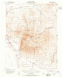
 1954 Alturas1968 Print · USGSThe Modoc Plateau and Surprise Valley appear in the mid-1950s as a landscape of remote ranching towns and vast wildlife refuges. Researchers can trace early settlements like Fort Bidwell, locate the McArthur Grain Elevator, and follow the Southern Pacific rail lines.4 unique versions available
 - 1955 Map of Loyalton, 1957 Print
 1955 Loyalton1957 Print · USGSThe Sierra Valley and the high timberlands of the California-Nevada border come alive in the mid-fifties. Genealogists can trace the Loyalton Cem and isolated outposts like Balls Ranch or the Flying Dutchman Mine.4 unique versions available
 - 1955 Map of Westwood, 1957 Print
 1955 Westwood1957 Print · USGSThe timber and ranching culture of the Lassen highlands is captured here during the mid-fifties. Genealogists and historians can trace family properties like Worley Ranch and Stephens Ranch or follow the rails to Westwood Junction.3 unique versions available
 - 1955 Map of Almanor, 1957 Print
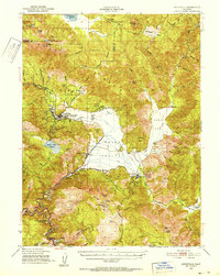
 1955 Almanor1957 Print · USGSThe high Sierra Nevada landscape is shaped by the massive reservoirs and mountain rail lines of the mid-fifties. Researchers can trace the Western Pacific route through the river canyons or locate mining history at the Dutch Hill Mine and Sunnyside Mine.4 unique versions available
 - 1955 Map of Westwood, 1959 Print
 1955 Westwood1959 Print · USGSIn the mid-fifties, the northeastern California interior supported a landscape of mountain timber and high-desert basins. Genealogists and historians can locate early settlements and industrial sites like Susanville, Herlong, and the Sierra Ordinance Depot.
 - 1955 Map of Lovelock, 1963 Print
 1955 Lovelock1963 Print · USGSNorthwestern Nevada’s vast desert basins and military ranges are captured here in the mid-fifties, showing a landscape defined by the Humboldt River and the great Pyramid Lake. Genealogists and historians can trace isolated rail stops like Gerlach and Empire, or locate historic workings such as the Golden Eagle Mine and Pershing Mine.5 unique versions available
 - 1956 Map of Hayden Hill, 1957 Print
 1956 Hayden Hill1957 Print · USGSThe high country of Lassen and Modoc counties comes into focus in the mid-1950s, revealing a landscape of high-altitude camps and essential waterholes. Researchers can trace the layout of Hayden Hill, locate the local Cem, or identify ranching landmarks like Totten Camp and Silva Flat Reservoir.3 unique versions available
 - 1956 Map of Mt. Harkness, 1958 Print
 1956 Mt. Harkness1958 Print · USGSThe high Cascades of Plumas and Tehama counties appear here during the mid-fifties, centered on the geothermal wonders of the national park. Genealogists and historians can locate remote outposts like Drakesbad, St Bernard, and the Smith Cabin among the peaks.4 unique versions available
 - 1956 Map of Chester, 1958 Print
 1956 Chester1958 Print · USGSMid-century Plumas County shows a landscape defined by the timber industry and the growing recreation of the Sierra Nevada. Trace the legacy of Westwood and Chester along the shores of Lake Almanor, or locate old rail grades like the Pacific Western Railroad.4 unique versions available
 - 1956 Map of Harvey Mtn, 1958 Print
 1956 Harvey Mtn1958 Print · USGSUpper Lassen County in the mid-fifties is captured here as a landscape of federal forestry and emerging mountain recreation. Researchers can trace historic administrative sites like Bogard Ranger Sta, remote outposts at Poison Station, and family-named cabins such as Longs Cabin.4 unique versions available
Showing maps 1-25 of 38
Top cities of Lassen County
- Susanville historical maps
- Janesville historical maps
- Westwood historical maps
- Johnstonville historical maps
- Patton Village historical maps
- Doyle historical maps
See more
Frequently asked questions
- What are the different types of historical maps available for Lassen County?
- What is the oldest map of Lassen County?
- Where can I purchase historical maps of Lassen County for my home or office?
- Where can I download high-res historical maps of Lassen County?
- Are there historical topographic maps available for Lassen County?
- Is there historical aerial imagery available for Lassen County?
- Where are historical maps of Lassen County sourced from?