1920s Maps of Covina, California
Explore 5 historic maps of Covina from the 1920s. These maps offer a rare glimpse into what life looked like during the 1920s — showing old roads, neighborhoods, homes, and landmarks that have changed or disappeared over time.
Whether you're researching your family's past, planning a metal detecting trip, or studying how Covina's landscape evolved across the 1920s, these high-resolution maps are a powerful tool for exploring the history of this region.
- Focus on a specific era: All maps on this page are from the 1920s, giving you a focused view of this time period.
- See what’s changed: Compare century-old streets, trails, and buildings to today's modern landscape using overlays and satellite layers.
- Research with precision: Use these maps for genealogy, historical research, land use analysis, or educational projects.
- View, download, or print: Maps are fully viewable online in high resolution, and can be downloaded or printed for your own records.
Start exploring Covina's history through authentic maps from the 1920s. This is your window into the past.
Covina, CA maps
(5)- 1925 Map of Azusa
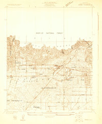 1925 Azusa1925 Print · USGSThe San Gabriel Valley comes alive in the mid-twenties as rail lines and citrus-era street grids expand toward the Sierra Madre. Trace family roots and local history at the Jewish Sanitarium, Live Oak Cemetery, or the old Kincaid Siding.
 - 1927 Map of Glendora
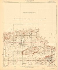 1927 Glendora1927 Print · USGSThe citrus-growing region of eastern Los Angeles County is captured here in the late twenties, showing the intersection of agricultural wealth and new mountain management. Genealogists and researchers can trace property lines near Glendora and San Dimas using landmarks like Citrus Union High School and the Pacific Electric rail line.2 unique versions available
 - 1927 Map of Covina
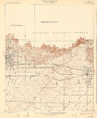
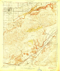 1927 Covina1927 Print · USGSThe eastern San Gabriel Valley was a thriving agricultural and transit hub in the 1920s, dominated by orchards and sprawling ranch lands. Genealogists can trace family roots through settlements like Covina, the Diamond Bar Ranch, and the Protestant Home for Boys.3 unique versions available
 - 1927 Map of Puente
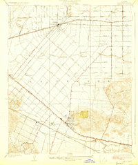 1927 Puente1927 Print · USGSThe San Gabriel Valley is shown in the late twenties during its era of agricultural prominence and early rail expansion. Genealogists can trace family tracts and rural community centers like Fellowship Farm, Temple Ranch, and the West Covina School.2 unique versions available
 - 1928 Map of Azusa
 1928 Azusa1928 Print · USGSThe San Gabriel Valley in the mid-twenties shows a thriving network of rail lines and citrus towns beneath the mountain peaks. Trace early residential footprints in Monrovia and Azusa, and locate landmarks like the Jewish Sanitarium and Irwindale school.3 unique versions available
End of results
Showing maps 1-5 of 5
Top cities near Covina
- Long Beach historical maps
- Anaheim historical maps
- Ontario historical maps
- Pomona historical maps
- Corona historical maps
- Pasadena historical maps
See more
Frequently asked questions
- What are the different types of historical maps available for Covina?
- What is the oldest map of Covina?
- Where can I purchase historical maps of Covina for my home or office?
- Where can I download high-res historical maps of Covina?
- Are there historical topographic maps available for Covina?
- Is there historical aerial imagery available for Covina?
- Where are historical maps of Covina sourced from?