1930s Maps of Desert View Highlands, California
Explore 2 historic maps of Desert View Highlands from the 1930s. These maps offer a rare glimpse into what life looked like during the 1930s — showing old roads, neighborhoods, homes, and landmarks that have changed or disappeared over time.
Whether you're researching your family's past, planning a metal detecting trip, or studying how Desert View Highlands's landscape evolved across the 1930s, these high-resolution maps are a powerful tool for exploring the history of this region.
- Focus on a specific era: All maps on this page are from the 1930s, giving you a focused view of this time period.
- See what’s changed: Compare century-old streets, trails, and buildings to today's modern landscape using overlays and satellite layers.
- Research with precision: Use these maps for genealogy, historical research, land use analysis, or educational projects.
- View, download, or print: Maps are fully viewable online in high resolution, and can be downloaded or printed for your own records.
Start exploring Desert View Highlands's history through authentic maps from the 1930s. This is your window into the past.
Desert View Highlands, CA maps
(2)- 1932 Map of Palmdale
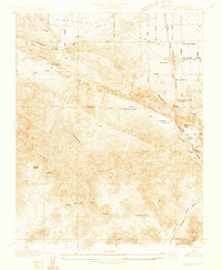 1932 Palmdale1932 Print · USGSPalmdale and the surrounding desert valleys are captured here in the early thirties as the region grew around rail and water infrastructure. Researchers can trace historic homesteads and facilities like the Palmdale Spring Sanitarium, City Ranch, and the Southern Pacific Railroad.
 - 1937 Map of Palmdale
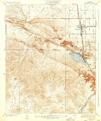 1937 Palmdale1937 Print · USGSAntelope Valley was a landscape of transit and ranching in the 1930s, centered on the railroad corridor and the rift valley. Genealogists can trace early landmarks like Casa del Adobe or follow the Southern Pacific tracks to the small settlements of Harold and Alpine.4 unique versions available
End of results
Showing maps 1-2 of 2
Top cities near Desert View Highlands
Frequently asked questions
- What are the different types of historical maps available for Desert View Highlands?
- What is the oldest map of Desert View Highlands?
- Where can I purchase historical maps of Desert View Highlands for my home or office?
- Where can I download high-res historical maps of Desert View Highlands?
- Are there historical topographic maps available for Desert View Highlands?
- Is there historical aerial imagery available for Desert View Highlands?
- Where are historical maps of Desert View Highlands sourced from?