1960s Maps of Glendale, California
Explore 6 historic maps of Glendale from the 1960s. These maps offer a rare glimpse into what life looked like during the 1960s — showing old roads, neighborhoods, homes, and landmarks that have changed or disappeared over time.
Whether you're researching your family's past, planning a metal detecting trip, or studying how Glendale's landscape evolved across the 1960s, these high-resolution maps are a powerful tool for exploring the history of this region.
- Focus on a specific era: All maps on this page are from the 1960s, giving you a focused view of this time period.
- See what’s changed: Compare century-old streets, trails, and buildings to today's modern landscape using overlays and satellite layers.
- Research with precision: Use these maps for genealogy, historical research, land use analysis, or educational projects.
- View, download, or print: Maps are fully viewable online in high resolution, and can be downloaded or printed for your own records.
Start exploring Glendale's history through authentic maps from the 1960s. This is your window into the past.
Glendale, CA maps
(6)- 1966 Map of Los Angeles
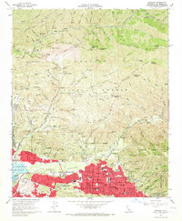
 1966 Los Angeles1966 Print · USGSSouthern California underwent a mid-century transformation as suburban grids reached the base of the San Gabriel Mountains. Researchers can trace the path of the Los Angeles Aqueduct or locate defense landmarks like Edwards Air Force Base.
 - 1966 Map of Sunland, 1967 Print
 1966 Sunland1967 Print · USGSThe foothills of the Verdugo Hills and the San Gabriel Mountains meet during the suburban expansion of the mid-sixties. Researchers can trace the development of Sunland and Tujunga, locating historic sites like the Lakeview Terrace Sanitarium, Hansen Dam, and the Angeles Gun Club.3 unique versions available
 - 1966 Map of Burbank, 1967 Print
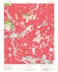
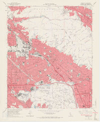 1966 Burbank1967 Print · USGSMid-century Los Angeles is on full display as the postwar suburbs expand into the Verdugo Mountains. Genealogists and historians can trace the growth of Burbank and Glendale alongside landmarks like Lockheed Air Terminal and the NBC-TV Studios.5 unique versions available
 - 1966 Map of Hollywood, 1968 Print
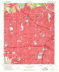 1966 Hollywood1968 Print · USGSLos Angeles and the Hollywood district are seen here at the peak of the mid-century era, showing a fully matured street grid and freeway system. Genealogists and historians can locate specific landmarks like Hollywood Memorial Park (Cem), Wrigley Field, and numerous local schools such as Fairfax High Sch.4 unique versions available
 - 1966 Map of Pasadena, 1968 Print
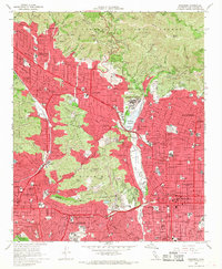 1966 Pasadena1968 Print · USGSMid-century Los Angeles County unfolds here during a period of rapid suburban and institutional growth. Researchers can trace the legacy of major landmarks like the Jet Propulsion Laboratory, the Rose Bowl, and the campus of Occidental College.5 unique versions available
 - 1966 Map of Los Angeles, 1968 Print
 1966 Los Angeles1968 Print · USGSLos Angeles and its eastern suburbs are shown here in the mid-sixties, a period of massive freeway expansion and urban density. Researchers can trace historic neighborhoods and landmarks like Dodger Stadium, Boyle Heights, and the expansive Evergreen Cemetery.5 unique versions available
End of results
Showing maps 1-6 of 6
Top cities near Glendale
- Los Angeles historical maps
- Santa Clarita historical maps
- Pasadena historical maps
- Inglewood historical maps
- Downey historical maps
- El Monte historical maps
See more
Top neighborhoods of Glendale
- Verdugo City historical maps
- Highway Highlands historical maps
- Glendale Civic Center historical maps
- Glendale City Center historical maps
- North Glendale historical maps
- Adams Square historical maps
See more
Frequently asked questions
- What are the different types of historical maps available for Glendale?
- What is the oldest map of Glendale?
- Where can I purchase historical maps of Glendale for my home or office?
- Where can I download high-res historical maps of Glendale?
- Are there historical topographic maps available for Glendale?
- Is there historical aerial imagery available for Glendale?
- Where are historical maps of Glendale sourced from?