1930s Maps of Altacanyada, La Cañada Flintridge
Explore 2 historic maps of Altacanyada from the 1930s. These maps offer a rare glimpse into what life looked like during the 1930s — showing old roads, neighborhoods, homes, and landmarks that have changed or disappeared over time.
Whether you're researching your family's past, planning a metal detecting trip, or studying how Altacanyada's landscape evolved across the 1930s, these high-resolution maps are a powerful tool for exploring the history of this region.
- Focus on a specific era: All maps on this page are from the 1930s, giving you a focused view of this time period.
- See what’s changed: Compare century-old streets, trails, and buildings to today's modern landscape using overlays and satellite layers.
- Research with precision: Use these maps for genealogy, historical research, land use analysis, or educational projects.
- View, download, or print: Maps are fully viewable online in high resolution, and can be downloaded or printed for your own records.
Start exploring Altacanyada's history through authentic maps from the 1930s. This is your window into the past.
Altacanyada, La Cañada Flintridge maps
(2)- 1933 Map of La Crescenta
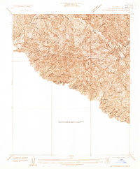 1933 La Crescenta1933 Print · USGSThe Los Angeles mountains in the 1930s reveal a specialized landscape of canyon retreats and early forest management. Local historians can trace the foundations of Hill Crest Sanatorium, the spiritual retreat at Anandra Ashrama, and the remote Big Tujunga Ranger Station.
 - 1939 Map of La Crescenta
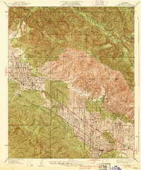 1939 La Crescenta1939 Print · USGSThe Crescenta Valley was rapidly developing into a series of foothill suburbs in the late thirties. Researchers can trace early street grids and landmarks like Hillcrest Sanitarium, the Burbank YMCA Camp, and the community of Verdugo City.4 unique versions available
End of results
Showing maps 1-2 of 2
Top cities near Altacanyada
- Los Angeles historical maps
- Glendale historical maps
- Santa Clarita historical maps
- Pasadena historical maps
- El Monte historical maps
- Burbank historical maps
See more
Frequently asked questions
- What are the different types of historical maps available for Altacanyada?
- What is the oldest map of Altacanyada?
- Where can I purchase historical maps of Altacanyada for my home or office?
- Where can I download high-res historical maps of Altacanyada?
- Are there historical topographic maps available for Altacanyada?
- Is there historical aerial imagery available for Altacanyada?
- Where are historical maps of Altacanyada sourced from?