1930s Maps of Lake Los Angeles, California
Explore 4 historic maps of Lake Los Angeles from the 1930s. These maps offer a rare glimpse into what life looked like during the 1930s — showing old roads, neighborhoods, homes, and landmarks that have changed or disappeared over time.
Whether you're researching your family's past, planning a metal detecting trip, or studying how Lake Los Angeles's landscape evolved across the 1930s, these high-resolution maps are a powerful tool for exploring the history of this region.
- Focus on a specific era: All maps on this page are from the 1930s, giving you a focused view of this time period.
- See what’s changed: Compare century-old streets, trails, and buildings to today's modern landscape using overlays and satellite layers.
- Research with precision: Use these maps for genealogy, historical research, land use analysis, or educational projects.
- View, download, or print: Maps are fully viewable online in high resolution, and can be downloaded or printed for your own records.
Start exploring Lake Los Angeles's history through authentic maps from the 1930s. This is your window into the past.
Lake Los Angeles, CA maps
(4)- 1930 Map of Lovejoy Springs
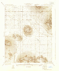 1930 Lovejoy Springs1930 Print · USGSAntelope Valley was a landscape of scattered homesteads and high-desert outposts in the early thirties. Researchers can trace the layout of early rural life near Wilsona Road, identifying the Wilsona Sch, the Yato Kya Desert Home, and Lovejoy Springs.
 - 1930 Map of Llano
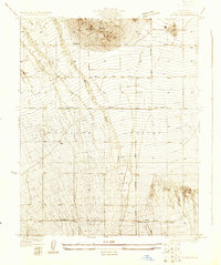 1930 Llano1930 Print · USGSAntelope Valley in the early 1930s shows a desert landscape undergoing the first major shifts of modern settlement. Researchers can trace the early road network including the Palmdale Victorville Road, the isolated Desert Relief, and the prominent Lovejoy Buttes.
 - 1933 Map of Lovejoy Springs
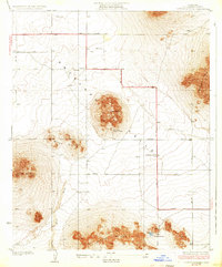 1933 Lovejoy Springs1933 Print · USGSAntelope Valley was a sparsely settled desert frontier in the early thirties, defined by its massive geological formations. Local historians can trace the foundations of this high-desert community through the Wilsona Sch, Lovejoy Springs, and the Yato Kya Desert Home.4 unique versions available
 - 1934 Map of Llano
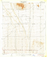 1934 Llano1934 Print · USGSThe High Desert of the mid-thirties comes to life in this survey of the eastern Antelope Valley. Researchers can trace early desert routes like the Palmdale Victorville Road and locate the early settlement of Llano near Desert Relief.4 unique versions available
End of results
Showing maps 1-4 of 4
Top cities near Lake Los Angeles
Frequently asked questions
- What are the different types of historical maps available for Lake Los Angeles?
- What is the oldest map of Lake Los Angeles?
- Where can I purchase historical maps of Lake Los Angeles for my home or office?
- Where can I download high-res historical maps of Lake Los Angeles?
- Are there historical topographic maps available for Lake Los Angeles?
- Is there historical aerial imagery available for Lake Los Angeles?
- Where are historical maps of Lake Los Angeles sourced from?