1930s Maps of Las Cantilles, California
Explore 2 historic maps of Las Cantilles from the 1930s. These maps offer a rare glimpse into what life looked like during the 1930s — showing old roads, neighborhoods, homes, and landmarks that have changed or disappeared over time.
Whether you're researching your family's past, planning a metal detecting trip, or studying how Las Cantilles's landscape evolved across the 1930s, these high-resolution maps are a powerful tool for exploring the history of this region.
- Focus on a specific era: All maps on this page are from the 1930s, giving you a focused view of this time period.
- See what’s changed: Compare century-old streets, trails, and buildings to today's modern landscape using overlays and satellite layers.
- Research with precision: Use these maps for genealogy, historical research, land use analysis, or educational projects.
- View, download, or print: Maps are fully viewable online in high resolution, and can be downloaded or printed for your own records.
Start exploring Las Cantilles's history through authentic maps from the 1930s. This is your window into the past.
Las Cantilles, CA maps
(2)- 1932 Map of La Brun
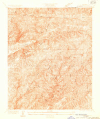 1932 La Brun1932 Print · USGSThe Los Angeles back country in the early thirties reveals a landscape of critical infrastructure carved into the mountains. Researchers can trace early utility corridors like the Aqueduct Tunnel and Power House No 1 among the slopes of Pelona Ridge.
 - 1937 Map of San Francisquito
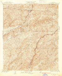 1937 San Francisquito1937 Print · USGSNorthern Los Angeles County in the mid-1930s reveals a mountain landscape defined by infrastructure and the Sierra Pelona. Trace the historic San Francisquito Power House No 1 and the waters of Bouquet Reservoir through this forest terrain.4 unique versions available
End of results
Showing maps 1-2 of 2
Top cities near Las Cantilles
- Los Angeles historical maps
- Santa Clarita historical maps
- Palmdale historical maps
- Lancaster historical maps
- Simi Valley historical maps
- San Fernando historical maps
See more
Frequently asked questions
- What are the different types of historical maps available for Las Cantilles?
- What is the oldest map of Las Cantilles?
- Where can I purchase historical maps of Las Cantilles for my home or office?
- Where can I download high-res historical maps of Las Cantilles?
- Are there historical topographic maps available for Las Cantilles?
- Is there historical aerial imagery available for Las Cantilles?
- Where are historical maps of Las Cantilles sourced from?