1920s Maps of Montecito Heights, Los Angeles
Explore 2 historic maps of Montecito Heights from the 1920s. These maps offer a rare glimpse into what life looked like during the 1920s — showing old roads, neighborhoods, homes, and landmarks that have changed or disappeared over time.
Whether you're researching your family's past, planning a metal detecting trip, or studying how Montecito Heights's landscape evolved across the 1920s, these high-resolution maps are a powerful tool for exploring the history of this region.
- Focus on a specific era: All maps on this page are from the 1920s, giving you a focused view of this time period.
- See what’s changed: Compare century-old streets, trails, and buildings to today's modern landscape using overlays and satellite layers.
- Research with precision: Use these maps for genealogy, historical research, land use analysis, or educational projects.
- View, download, or print: Maps are fully viewable online in high resolution, and can be downloaded or printed for your own records.
Start exploring Montecito Heights's history through authentic maps from the 1920s. This is your window into the past.
Montecito Heights, Los Angeles maps
(2)- 1924 Map of Alhambra
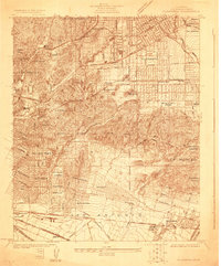 1924 Alhambra1924 Print · USGSThe Los Angeles basin is captured here during the mid-twenties as streetcar suburbs and oil derricks began to reshape the landscape. Genealogists and researchers can trace early neighborhoods like Belvidere Gardens or locate family sites near Evergreen Cem and Granada School.
 - 1926 Map of Alhambra
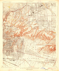 1926 Alhambra1926 Print · USGSAlhambra and its neighboring suburbs in the mid-twenties show a landscape transitioning from rural ranchos to dense residential grids. Genealogists and historians can trace family locations near San Gabriel Mission, Evergreen Cemetery, and early schools like Granada School.4 unique versions available
End of results
Showing maps 1-2 of 2
Frequently asked questions
- What are the different types of historical maps available for Montecito Heights?
- What is the oldest map of Montecito Heights?
- Where can I purchase historical maps of Montecito Heights for my home or office?
- Where can I download high-res historical maps of Montecito Heights?
- Are there historical topographic maps available for Montecito Heights?
- Is there historical aerial imagery available for Montecito Heights?
- Where are historical maps of Montecito Heights sourced from?