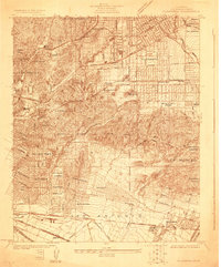
1924 Map of Alhambra
USGS Topo · Published 1924About this map
Alhambra and Monterey Park define the eastern portion of this Los Angeles basin survey, showing a landscape in the midst of rapid residential and industrial subdivision. The region is heavily influenced by the presence of the Pacific Electric and Southern Pacific rail lines, which facilitated the growth of neighborhoods like Sierra Vista, Shorb, and Belvidere Gardens. To the west, the steep hills of El Sereno and City Terrace provide a stark topographical contrast to the gridded streets of Boyle Heights. Large religious and social institutions occupy significant tracts, notably the Convent of the Holy Name and the Midwick Country Club. The presence of the Standard Oil Co Oil Wells near Montebello and the Stockyard in Vernon reflects the diverse economic base of the era, while extensive burial grounds such as Evergreen Cem and New Calvary Cemetery serve the expanding population centers.
Find a feature on this map
57 named features on this map. Tap any name to fly to it.
Don’t see what you’re looking for? This feature index may not catch every label — zoom into the map to look around manually.
Map Details
Editions of this 1924 Alhambra Map
This is the sole edition of this map. No revisions or reprints were ever made.
Other maps of this area

1894 · Los Angeles
USGS Topo · 1:62,500

1896 · Pasadena
USGS Topo · 1:62,500

1896 · Downey
USGS Topo · 1:62,500

1899 · Downey
USGS Topo · 1:62,500

1900 · Pasadena
USGS Topo · 1:62,500

1900 · Los Angeles
USGS Topo · 1:62,500

1901 · Southern California Sheet No. 1
USGS Topo · 1:250,000

1902 · Downey
USGS Topo · 1:62,500

1904 · Southern California Sheet No. 1
USGS Topo · 1:250,000
1923 · Bell
USGS Topo · 1:24,000