1960s Maps of North Hills East Neighborhood Council District, Los Angeles
Explore 3 historic maps of North Hills East Neighborhood Council District from the 1960s. These maps offer a rare glimpse into what life looked like during the 1960s — showing old roads, neighborhoods, homes, and landmarks that have changed or disappeared over time.
Whether you're researching your family's past, planning a metal detecting trip, or studying how North Hills East Neighborhood Council District's landscape evolved across the 1960s, these high-resolution maps are a powerful tool for exploring the history of this region.
- Focus on a specific era: All maps on this page are from the 1960s, giving you a focused view of this time period.
- See what’s changed: Compare century-old streets, trails, and buildings to today's modern landscape using overlays and satellite layers.
- Research with precision: Use these maps for genealogy, historical research, land use analysis, or educational projects.
- View, download, or print: Maps are fully viewable online in high resolution, and can be downloaded or printed for your own records.
Start exploring North Hills East Neighborhood Council District's history through authentic maps from the 1960s. This is your window into the past.
North Hills East Neighborhood Council District, Los Angeles maps
(3)- 1966 Map of Los Angeles
 1966 Los Angeles1966 Print · USGSSouthern California underwent a mid-century transformation as suburban grids reached the base of the San Gabriel Mountains. Researchers can trace the path of the Los Angeles Aqueduct or locate defense landmarks like Edwards Air Force Base.
 - 1966 Map of San Fernando, 1967 Print
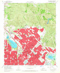 1966 San Fernando1967 Print · USGSThe San Fernando Valley was undergoing a massive suburban expansion in the mid-1960s as major freeways reshaped the northern Los Angeles landscape. Researchers can trace the development of Sylmar and Pacoima, locate historic grounds like San Fernando Mission Cem, and see the footprint of Van Norman Lake before its reconfiguration.3 unique versions available
 - 1966 Map of Van Nuys, 1968 Print
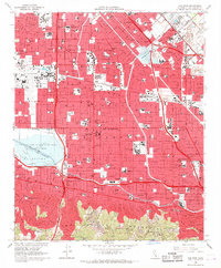 1966 Van Nuys1968 Print · USGSThe San Fernando Valley of the mid-sixties is a landscape of rapid suburban growth and massive infrastructure projects. Researchers can trace the legacy of local institutions from Van Nuys Airport to the Los Encinos State Historical Monument.4 unique versions available
End of results
Showing maps 1-3 of 3
Frequently asked questions
- What are the different types of historical maps available for North Hills East Neighborhood Council District?
- What is the oldest map of North Hills East Neighborhood Council District?
- Where can I purchase historical maps of North Hills East Neighborhood Council District for my home or office?
- Where can I download high-res historical maps of North Hills East Neighborhood Council District?
- Are there historical topographic maps available for North Hills East Neighborhood Council District?
- Is there historical aerial imagery available for North Hills East Neighborhood Council District?
- Where are historical maps of North Hills East Neighborhood Council District sourced from?