Old Maps of Silver Triangle, Los Angeles for Genealogy
Trace your family roots with 22 historic maps of Silver Triangle. These high-res maps reveal old neighborhoods, homesites, landmarks, and streets — helping you uncover where your ancestors lived and how the area evolved over time.
- Explore historic neighborhoods: Identify where your relatives may have lived in the 1800s or 1900s.
- Compare maps over time: Trace the changes in streets, buildings, and landmarks for multi-generational research.
- Perfect for genealogy & ancestry research: Used by family historians and researchers to map out lineage and migration.
These maps are an incredible resource for exploring your personal connection to Silver Triangle's past.
Silver Triangle, Los Angeles maps
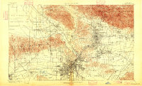
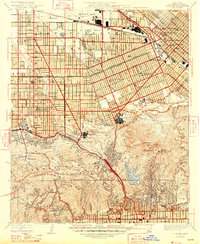
(22)- 1894 Map of Los Angeles
 1894 Los Angeles1894 Print · USGSCovers Silver Triangle, including Los Angeles, Glendale, and other nearby areas2 unique versions available
 - 1896 Map of Santa Monica
 1896 Santa Monica1896 Print · USGSCovers Silver Triangle, including Los Angeles, Glendale, and other nearby areas
 - 1898 Map of Santa Monica
 1898 Santa Monica1898 Print · USGSCovers Silver Triangle, including Los Angeles, Glendale, and other nearby areas
 - 1900 Map of Los Angeles
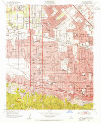
 1900 Los Angeles1900 Print · USGSCovers Silver Triangle, including Los Angeles, Glendale, and other nearby areas8 unique versions available
 - 1901 Map of Southern California Sheet No. 1
 1901 Southern California Sheet No. 11901 Print · USGSCovers Silver Triangle, including Los Angeles, Long Beach, and other nearby areas11 unique versions available
 - 1902 Map of Santa Monica
 1902 Santa Monica1902 Print · USGSCovers Silver Triangle, including Los Angeles, Glendale, and other nearby areas4 unique versions available
 - 1904 Map of Southern California Sheet No. 1, 1905 Print
 1904 Southern California Sheet No. 11905 Print · USGSCovers Silver Triangle, including Los Angeles, Long Beach, and other nearby areas3 unique versions available
 - 1920 Map of Santa Monica
 1920 Santa Monica1920 Print · USGSCovers Silver Triangle, including Los Angeles, Glendale, and other nearby areas
 - 1921 Map of Santa Monica
 1921 Santa Monica1921 Print · USGSCovers Silver Triangle, including Los Angeles, Glendale, and other nearby areas3 unique versions available
 - 1924 Map of Van Nuys
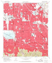
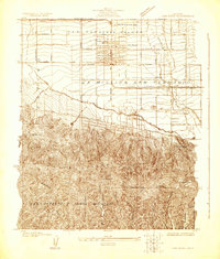 1924 Van Nuys1924 Print · USGSCovers Silver Triangle, including Los Angeles, Beverly Hills, and other nearby areas
 - 1926 Map of Van Nuys
 1926 Van Nuys1926 Print · USGSCovers Silver Triangle, including Los Angeles, Beverly Hills, and other nearby areas4 unique versions available
 - 1926 Map of Burbank
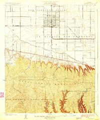
 1926 Burbank1926 Print · USGSCovers Silver Triangle, including Los Angeles, Glendale, and other nearby areas3 unique versions available
 - 1948 Map of Burbank
 1948 Burbank1948 Print · USGSCovers Silver Triangle, including Los Angeles, Glendale, and other nearby areas
 - 1949 Map of Los Angeles
 1949 Los Angeles1949 Print · USGSCovers Silver Triangle, including Los Angeles, Oxnard, and other nearby areas3 unique versions available
 - 1953 Map of Van Nuys, 1955 Print
 1953 Van Nuys1955 Print · USGSCovers Silver Triangle, including Los Angeles, Los Angeles County, and other nearby areas2 unique versions available
 - 1955 Map of Los Angeles
 1955 Los Angeles1955 Print · USGSCovers Silver Triangle, including Los Angeles, Oxnard, and other nearby areas
 - 1959 Map of Los Angeles
 1959 Los Angeles1959 Print · USGSCovers Silver Triangle, including Los Angeles, Oxnard, and other nearby areas3 unique versions available
 - 1966 Map of Los Angeles
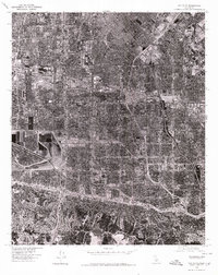
 1966 Los Angeles1966 Print · USGSCovers Silver Triangle, including Los Angeles, Oxnard, and other nearby areas
 - 1966 Map of Van Nuys, 1968 Print
 1966 Van Nuys1968 Print · USGSCovers Silver Triangle, including Los Angeles, Los Angeles County, and other nearby areas4 unique versions available
 - 1975 Map of Los Angeles, 1977 Print
 1975 Los Angeles1977 Print · USGSCovers Silver Triangle, including Los Angeles, Oxnard, and other nearby areas2 unique versions available
 - 1976 Map of Van Nuys, 1980 Print
 1976 Van Nuys1980 Print · USGSCovers Silver Triangle, including Los Angeles, Los Angeles County, and other nearby areas
 - 1979 Map of Los Angeles
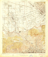
 1979 Los Angeles1979 Print · USGSCovers Silver Triangle, including Los Angeles, Glendale, and other nearby areas
End of results
Showing maps 1-22 of 22
Frequently asked questions
- What are the different types of historical maps available for Silver Triangle?
- What is the oldest map of Silver Triangle?
- Where can I purchase historical maps of Silver Triangle for my home or office?
- Where can I download high-res historical maps of Silver Triangle?
- Are there historical topographic maps available for Silver Triangle?
- Is there historical aerial imagery available for Silver Triangle?
- Where are historical maps of Silver Triangle sourced from?