1920s Maps of Tree Section, Manhattan Beach
Explore 4 historic maps of Tree Section from the 1920s. These maps offer a rare glimpse into what life looked like during the 1920s — showing old roads, neighborhoods, homes, and landmarks that have changed or disappeared over time.
Whether you're researching your family's past, planning a metal detecting trip, or studying how Tree Section's landscape evolved across the 1920s, these high-resolution maps are a powerful tool for exploring the history of this region.
- Focus on a specific era: All maps on this page are from the 1920s, giving you a focused view of this time period.
- See what’s changed: Compare century-old streets, trails, and buildings to today's modern landscape using overlays and satellite layers.
- Research with precision: Use these maps for genealogy, historical research, land use analysis, or educational projects.
- View, download, or print: Maps are fully viewable online in high resolution, and can be downloaded or printed for your own records.
Start exploring Tree Section's history through authentic maps from the 1920s. This is your window into the past.
Tree Section, Manhattan Beach maps
(4)- 1923 Map of Venice
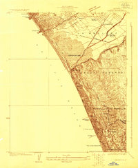 1923 Venice1923 Print · USGSThe Los Angeles coastline was a mix of seaside resorts and industrial pioneers in the early twenties. Genealogists and historians can trace early residential blocks in Venice or locate vanished landmarks like the Del Rey Gun Club and the Standard Oil Refinery.
 - 1924 Map of Inglewood
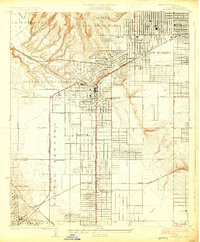 1924 Inglewood1924 Print · USGSCoastal Los Angeles County is seen in the mid-twenties as the oil and rail industries reshaped the land. Trace early schools and industrial roots like the Standard Oil Company, the Naval Radio Sta, and the Pacific Electric lines.
 - 1924 Map of Torrance
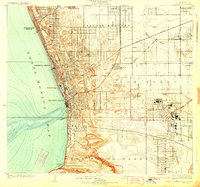 1924 Torrance1924 Print · USGSThe South Bay of Los Angeles is captured here in the mid-1920s as coastal resort towns and industrial hubs like Torrance began to flourish. Researchers can trace the early rail-driven economy through the Pacific Electric Car Shops, Llewellyn Iron Works, and the seaside Pacific Electric Pier.2 unique versions available
 - 1924 Map of Venice
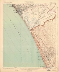 1924 Venice1924 Print · USGSThe Los Angeles coastline in the mid-twenties shows a rapidly developing landscape of seaside piers and industrial refineries. Trace early transit routes along the Pacific Electric railway and locate vanished landmarks like the Motordrome or the Recreation Gun Club.3 unique versions available
End of results
Showing maps 1-4 of 4
Frequently asked questions
- What are the different types of historical maps available for Tree Section?
- What is the oldest map of Tree Section?
- Where can I purchase historical maps of Tree Section for my home or office?
- Where can I download high-res historical maps of Tree Section?
- Are there historical topographic maps available for Tree Section?
- Is there historical aerial imagery available for Tree Section?
- Where are historical maps of Tree Section sourced from?