1940s Maps of Paradise Springs, California
Explore 2 historic maps of Paradise Springs from the 1940s. These maps offer a rare glimpse into what life looked like during the 1940s — showing old roads, neighborhoods, homes, and landmarks that have changed or disappeared over time.
Whether you're researching your family's past, planning a metal detecting trip, or studying how Paradise Springs's landscape evolved across the 1940s, these high-resolution maps are a powerful tool for exploring the history of this region.
- Focus on a specific era: All maps on this page are from the 1940s, giving you a focused view of this time period.
- See what’s changed: Compare century-old streets, trails, and buildings to today's modern landscape using overlays and satellite layers.
- Research with precision: Use these maps for genealogy, historical research, land use analysis, or educational projects.
- View, download, or print: Maps are fully viewable online in high resolution, and can be downloaded or printed for your own records.
Start exploring Paradise Springs's history through authentic maps from the 1940s. This is your window into the past.
Paradise Springs, CA maps
(2)- 1940 Map of Rock Creek, 1955 Print
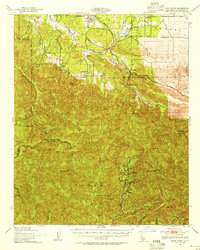 1940 Rock Creek1955 Print · USGSHigh desert settlements and steep mountain peaks meet in this mid-century look at the eastern San Gabriel range. Researchers can trace the path of the Andreas Rift Zone and locate early ranch sites like Saunders Ranch and the community of Valyermo.
 - 1941 Map of Crystal Lake
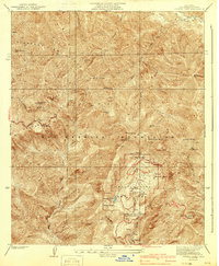 1941 Crystal Lake1941 Print · USGSThe high San Gabriel Mountains are captured here in the early 1940s, just as mountain recreation was becoming formalized in the national forest. Researchers can trace early resort and camp footprints at Wawona Lodge and the Crystal Lake Camp Area, or locate remote landmarks like the YMCA Hut.4 unique versions available
End of results
Showing maps 1-2 of 2
Top cities near Paradise Springs
- Rancho Cucamonga historical maps
- Palmdale historical maps
- Arcadia historical maps
- Glendora historical maps
- Monrovia historical maps
- Duarte historical maps
See more
Frequently asked questions
- What are the different types of historical maps available for Paradise Springs?
- What is the oldest map of Paradise Springs?
- Where can I purchase historical maps of Paradise Springs for my home or office?
- Where can I download high-res historical maps of Paradise Springs?
- Are there historical topographic maps available for Paradise Springs?
- Is there historical aerial imagery available for Paradise Springs?
- Where are historical maps of Paradise Springs sourced from?