1920s Maps of Pico Rivera, California
Explore 8 historic maps of Pico Rivera from the 1920s. These maps offer a rare glimpse into what life looked like during the 1920s — showing old roads, neighborhoods, homes, and landmarks that have changed or disappeared over time.
Whether you're researching your family's past, planning a metal detecting trip, or studying how Pico Rivera's landscape evolved across the 1920s, these high-resolution maps are a powerful tool for exploring the history of this region.
- Focus on a specific era: All maps on this page are from the 1920s, giving you a focused view of this time period.
- See what’s changed: Compare century-old streets, trails, and buildings to today's modern landscape using overlays and satellite layers.
- Research with precision: Use these maps for genealogy, historical research, land use analysis, or educational projects.
- View, download, or print: Maps are fully viewable online in high resolution, and can be downloaded or printed for your own records.
Start exploring Pico Rivera's history through authentic maps from the 1920s. This is your window into the past.
Pico Rivera, CA maps
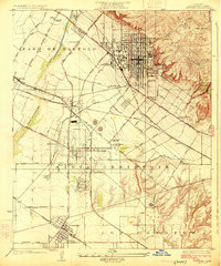
(8)- 1923 Map of Bell
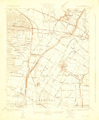 1923 Bell1923 Print · USGSLos Angeles County was rapidly urbanizing in the early twenties as residential tracts replaced citrus groves and ranchlands. Genealogists can trace family footprints through the numerous local schools like Old River School or find historical industrial sites such as the Rio Grande Oil Co.
 - 1923 Map of El Monte
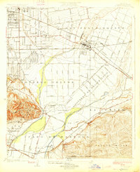
 1923 El Monte1923 Print · USGSThe San Gabriel Valley was a thriving agricultural and rail corridor in the years following the Great War. You can trace early township boundaries and find the sites of rural schools and industry, from the O'Donnel Oil Refinery to the Temple School.
 - 1923 Map of Whittier
 1923 Whittier1923 Print · USGSSoutheast Los Angeles County is captured here in the early twenties during a period of rapid agricultural and industrial expansion. Genealogists and local historians can trace the foundations of Santa Fe Springs and Colima, or locate family sites near Little Lake School and Mt Olive Cem.
 - 1924 Map of Alhambra
 1924 Alhambra1924 Print · USGSThe Los Angeles basin is captured here during the mid-twenties as streetcar suburbs and oil derricks began to reshape the landscape. Genealogists and researchers can trace early neighborhoods like Belvidere Gardens or locate family sites near Evergreen Cem and Granada School.
 - 1925 Map of Whittier
 1925 Whittier1925 Print · USGSLos Angeles County during the 1920s petroleum boom reveals a landscape of expanding towns and industrial grit. Researchers can trace the early footprints of Santa Fe Springs, the sprawling Oil Wells, and local institutions like the Norwalk State Hospital.2 unique versions available
 - 1925 Map of Bell
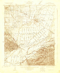
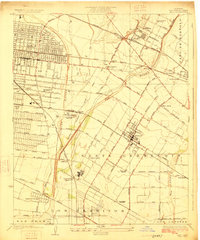 1925 Bell1925 Print · USGSSoutheast Los Angeles during the mid-twenties shows a landscape of growing towns and industrial expansion between the river forks. Genealogists and researchers can trace early neighborhoods in Bell and Maywood or locate landmarks like the County Farm Hondo PO and Rio Grande Oil Refinery.2 unique versions available
 - 1926 Map of El Monte
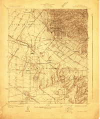
 1926 El Monte1926 Print · USGSThe San Gabriel Valley in the mid-twenties shows a landscape of historic ranchos transitioning into suburban clusters along the rail lines. Genealogists and researchers can trace early homesteads and schools like Temple School or the industrial footprint of the O'Donnel Oil Refinery.2 unique versions available
 - 1926 Map of Alhambra
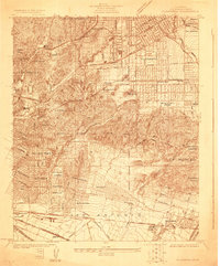
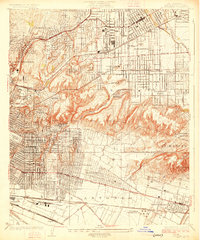 1926 Alhambra1926 Print · USGSAlhambra and its neighboring suburbs in the mid-twenties show a landscape transitioning from rural ranchos to dense residential grids. Genealogists and historians can trace family locations near San Gabriel Mission, Evergreen Cemetery, and early schools like Granada School.4 unique versions available
End of results
Showing maps 1-8 of 8
Top cities near Pico Rivera
- Los Angeles historical maps
- Long Beach historical maps
- Anaheim historical maps
- Santa Ana historical maps
- Irvine historical maps
- Glendale historical maps
See more
Top neighborhoods of Pico Rivera
Frequently asked questions
- What are the different types of historical maps available for Pico Rivera?
- What is the oldest map of Pico Rivera?
- Where can I purchase historical maps of Pico Rivera for my home or office?
- Where can I download high-res historical maps of Pico Rivera?
- Are there historical topographic maps available for Pico Rivera?
- Is there historical aerial imagery available for Pico Rivera?
- Where are historical maps of Pico Rivera sourced from?