Old Maps of Portuguese Bend, Rancho Palos Verdes for Metal Detecting
Plan your next treasure hunt with 19 historic maps of Portuguese Bend. Find old homesites, ghost towns, trails, and gathering spots that may be lost to time — perfect for identifying promising metal detecting locations.
- Locate forgotten sites: Uncover places like long-lost settlements, abandoned rail lines, or gathering spots.
- Plan better hunts: Use map overlays combined with LiDAR or satellite views to narrow in on historically rich areas.
- Made for detectorists: Thousands of hobbyists use these maps to discover relics, coins, and hidden history.
Use these historic maps to boost your research and find new opportunities beneath the surface of Portuguese Bend.
Portuguese Bend, Rancho Palos Verdes maps
(19)- 1896 Map of San Pedro
 1896 San Pedro1896 Print · USGSThe Los Angeles coast near the turn of the century shows the maritime roots of the South Bay before the harbor was fully transformed. Genealogists and historians can trace early rail lines like the L. A. Terminal R. R. and vanished island landmarks like Deadman Id. and Rattlesnake Id.5 unique versions available
 - 1901 Map of Southern California Sheet No. 1
 1901 Southern California Sheet No. 11901 Print · USGSGreater Los Angeles at the dawn of the twentieth century is a landscape of growing citrus towns and a burgeoning rail network. Genealogists and historians can trace the early gridded streets of Hollywood and Pasadena or locate landmarks like Bear Lake and the Cahuilla Indian Reservation.6 unique versions available
 - 1904 Map of Southern California Sheet No. 1, 1905 Print
 1904 Southern California Sheet No. 11905 Print · USGSSouthern California at the dawn of the twentieth century shows a landscape of citrus groves and coastal towns connected by rail. Genealogists and historians can trace early settlements like San Juan Capistrano, find remote sites like the Rose Mine, and study the original water systems of the Santa Ana River.2 unique versions available
 - 1925 Map of San Pedro Hills
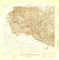 1925 San Pedro Hills1925 Print · USGSThe Palos Verdes Peninsula is captured during the mid-twenties, showing a landscape of dramatic coastal bluffs and early hilltop developments. Trace early roads and land use at the Palos Verdes Club and the coastal settlements of San Pedro and Walteria.
 - 1928 Map of San Pedro Hills
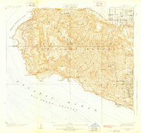 1928 San Pedro Hills1928 Print · USGSThe Los Angeles coastline and San Pedro Hills are seen here in the late twenties, during the early development of Palos Verdes Estates. Trace the beginnings of coastal life through landmarks like Whites Point Hot Springs, the Palos Verdes Golf Club, and Point Vicente.3 unique versions available
 - 1942 Map of San Pedro Hill
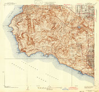 1942 San Pedro Hill1942 Print · USGSThe Palos Verdes Peninsula was just beginning its modern expansion in the early 1940s, balancing coastal estates with early industrial grids. Trace the development of Palos Verdes Estates, locate the Whites Point Hot Springs, or study the early layout of Lomita.
 - 1943 Map of San Pedro
 1943 San Pedro1943 Print · USGSThe South Bay and Los Angeles Harbor area appear here during the Second World War, showing a landscape of burgeoning industry and aviation. Trace wartime infrastructure and local landmarks like Hughes Airport, Terminal Island, and Inglewood Park Cem.
 - 1944 Map of San Pedro
 1944 San Pedro1944 Print · USGSCoastal California at the height of the war reveals a landscape of strategic defense and maritime industry. Researchers can trace the military boundaries of Fort Mac Arthur and find coastal landmarks like Point Fermin and Abalone Cove.
 - 1949 Map of Long Beach
 1949 Long Beach1949 Print · USGSSouthern California at the start of the post-war boom shows the rapid development of the Los Angeles basin and the South Bay. Genealogists and historians can trace the evolution of early suburbs like Gardena and Lynwood or the coastal defenses at Ft MacArthur Lower Reservation.2 unique versions available
 - 1951 Map of San Pedro, 1953 Print
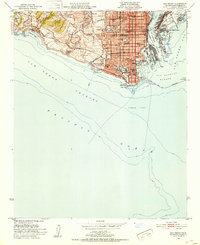 1951 San Pedro1953 Print · USGSCoastal Los Angeles at the dawn of the fifties shows a high-density harbor and military landscape. Trace the strategic layout of Fort Mac Arthur, the industrial works on Terminal Island, and family landmarks like Holy Trinity Sch.2 unique versions available
 - 1957 Map of Long Beach
 1957 Long Beach1957 Print · USGSThe Los Angeles coast and the Channel Islands appear here during the mid-fifties era of rapid suburbanization and naval expansion. Genealogists and researchers can locate early industrial neighborhoods like South Gate and trace military boundaries at Ft MacArthur Upper Reservation or the remote San Nicolas Island.4 unique versions available
 - 1958 Map of Long Beach
 1958 Long Beach1958 Print · USGSCoastal Southern California is shown during a mid-century period of intense suburbanization and military readiness. Genealogists and historians can trace the growth of Long Beach, identify early neighborhoods in Lakewood Village, or locate the bounds of Ft MacArthur Lower Reservation.
 - 1960 Map of Long Beach
 1960 Long Beach1960 Print · USGSCoastal California at the height of post-war expansion reveals a dense network of suburban growth and maritime industry. Trace the development of the South Bay and inland neighborhoods like Lakewood Village, or explore the topography of Santa Catalina Island and Los Angeles Harbor.2 unique versions available
 - 1964 Map of San Pedro, 1965 Print
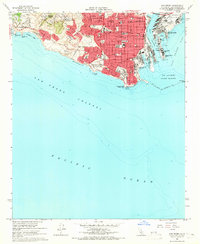 1964 San Pedro1965 Print · USGSSan Pedro and the Palos Verdes coastline are captured in the mid-sixties, just as the Vincent Thomas Bridge reshaped the harbor's profile. Researchers can trace the extensive footprints of Fort MacArthur and the industrial layout of Terminal Island and Fish Harbor.3 unique versions available
 - 1981 Map of Long Beach
 1981 Long Beach1981 Print · USGSCoastal Los Angeles and the South Bay reached a peak of industrial and suburban maturity in the early eighties. Researchers can trace the development of aerospace and maritime hubs through landmarks like the Queen Mary, Fort MacArthur, and Signal Hill.3 unique versions available
 - 2012 Map of San Pedro, 2012 Print
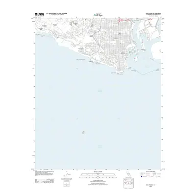 2012 San Pedro2012 Print · USGSCovers Portuguese Bend, including Los Angeles, Rancho Palos Verdes, and other nearby areas
 - 2015 Map of San Pedro, 2015 Print
 2015 San Pedro2015 Print · USGSCovers Portuguese Bend, including Los Angeles, Rancho Palos Verdes, and other nearby areas
 - 2018 Map of San Pedro, 2018 Print
 2018 San Pedro2018 Print · USGSCovers Portuguese Bend, including Los Angeles, Rancho Palos Verdes, and other nearby areas
 - 2021 Map of San Pedro, 2021 Print
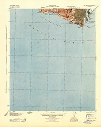
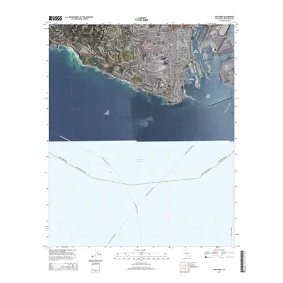
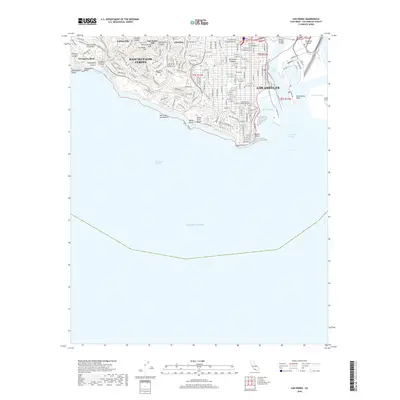
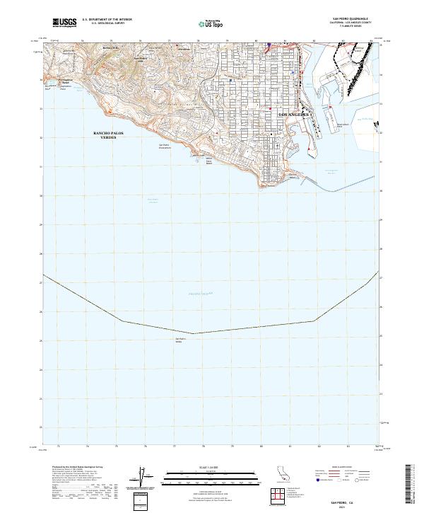 2021 San Pedro2021 Print · USGSThe Los Angeles waterfront and the Palos Verdes Peninsula come into sharp focus in this recent survey. Researchers can trace the rugged coastal topography from Portuguese Bend to the industrial piers of Terminal Island and Los Angeles Harbor.
End of results
Showing maps 1-19 of 19
Top cities near Portuguese Bend
- Los Angeles historical maps
- Long Beach historical maps
- Torrance historical maps
- Inglewood historical maps
- Downey historical maps
- Compton historical maps
See more
Frequently asked questions
- What are the different types of historical maps available for Portuguese Bend?
- What is the oldest map of Portuguese Bend?
- Where can I purchase historical maps of Portuguese Bend for my home or office?
- Where can I download high-res historical maps of Portuguese Bend?
- Are there historical topographic maps available for Portuguese Bend?
- Is there historical aerial imagery available for Portuguese Bend?
- Where are historical maps of Portuguese Bend sourced from?