1950s Maps of Torrance, California
Explore 6 historic maps of Torrance from the 1950s. These maps offer a rare glimpse into what life looked like during the 1950s — showing old roads, neighborhoods, homes, and landmarks that have changed or disappeared over time.
Whether you're researching your family's past, planning a metal detecting trip, or studying how Torrance's landscape evolved across the 1950s, these high-resolution maps are a powerful tool for exploring the history of this region.
- Focus on a specific era: All maps on this page are from the 1950s, giving you a focused view of this time period.
- See what’s changed: Compare century-old streets, trails, and buildings to today's modern landscape using overlays and satellite layers.
- Research with precision: Use these maps for genealogy, historical research, land use analysis, or educational projects.
- View, download, or print: Maps are fully viewable online in high resolution, and can be downloaded or printed for your own records.
Start exploring Torrance's history through authentic maps from the 1950s. This is your window into the past.
Torrance, CA maps
(6)- 1950 Map of Inglewood, 1957 Print
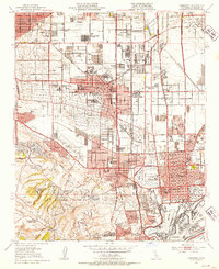
 1950 Inglewood1957 Print · USGSMid-century Los Angeles County is captured here during a period of intense postwar suburban and industrial growth. Genealogists and local historians can trace the foundations of Inglewood and Hawthorne, locating landmarks like the Inglewood Park Cemetery and the Gardena Valley Airport.
 - 1951 Map of Torrance, 1953 Print
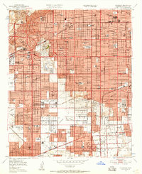
 1951 Torrance1953 Print · USGSThe South Bay transitioned from an oil-rich landscape to a suburban powerhouse during the early fifties. Genealogists and historians can trace mid-century neighborhoods like Avalon Village and local institutions such as Los Angeles Harbor Junior College.2 unique versions available
 - 1951 Map of Redondo Beach, 1953 Print
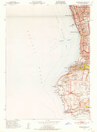 1951 Redondo Beach1953 Print · USGSCoastal Los Angeles County comes alive in the early fifties, capturing the dense shoreline of Redondo Beach as it pushes toward the peninsula. Trace the development of neighborhood schools like Beryl Hts Sch and iconic landmarks like the Wayfarers Chapel.2 unique versions available
 - 1952 Map of Inglewood
 1952 Inglewood1952 Print · USGSMid-century Los Angeles County undergoes massive post-war expansion across the South Bay and Centinela Valley. Genealogists can locate family homes near Hollywood Park, Inglewood Park Cemetery, and the Gardena Valley Airport.
 - 1957 Map of Long Beach
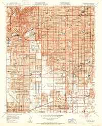
 1957 Long Beach1957 Print · USGSThe Los Angeles coast and the Channel Islands appear here during the mid-fifties era of rapid suburbanization and naval expansion. Genealogists and researchers can locate early industrial neighborhoods like South Gate and trace military boundaries at Ft MacArthur Upper Reservation or the remote San Nicolas Island.4 unique versions available
 - 1958 Map of Long Beach
 1958 Long Beach1958 Print · USGSCoastal Southern California is shown during a mid-century period of intense suburbanization and military readiness. Genealogists and historians can trace the growth of Long Beach, identify early neighborhoods in Lakewood Village, or locate the bounds of Ft MacArthur Lower Reservation.
End of results
Showing maps 1-6 of 6
Top cities near Torrance
- Los Angeles historical maps
- Long Beach historical maps
- Inglewood historical maps
- Compton historical maps
- South Gate historical maps
- Carson historical maps
See more
Top neighborhoods of Torrance
- Bridgedale historical maps
- Southwest Village historical maps
- Walteria historical maps
- Perry historical maps
- Moneta historical maps
- Dudmore historical maps
See more
Frequently asked questions
- What are the different types of historical maps available for Torrance?
- What is the oldest map of Torrance?
- Where can I purchase historical maps of Torrance for my home or office?
- Where can I download high-res historical maps of Torrance?
- Are there historical topographic maps available for Torrance?
- Is there historical aerial imagery available for Torrance?
- Where are historical maps of Torrance sourced from?