1930s Maps of Unincorporated Chatsworth, California
Explore 3 historic maps of Unincorporated Chatsworth from the 1930s. These maps offer a rare glimpse into what life looked like during the 1930s — showing old roads, neighborhoods, homes, and landmarks that have changed or disappeared over time.
Whether you're researching your family's past, planning a metal detecting trip, or studying how Unincorporated Chatsworth's landscape evolved across the 1930s, these high-resolution maps are a powerful tool for exploring the history of this region.
- Focus on a specific era: All maps on this page are from the 1930s, giving you a focused view of this time period.
- See what’s changed: Compare century-old streets, trails, and buildings to today's modern landscape using overlays and satellite layers.
- Research with precision: Use these maps for genealogy, historical research, land use analysis, or educational projects.
- View, download, or print: Maps are fully viewable online in high resolution, and can be downloaded or printed for your own records.
Start exploring Unincorporated Chatsworth's history through authentic maps from the 1930s. This is your window into the past.
Unincorporated Chatsworth, CA maps
(3)- 1932 Map of Zelzah
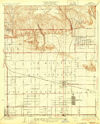 1932 Zelzah1932 Print · USGSThe San Fernando Valley is seen here during its agricultural peak in the early thirties, just as early poultry colonies were defining the local economy. Genealogists and historians can trace the foundations of Canoga Park and Reseda, alongside unique sites like the Runnymede Poultry Colony.
 - 1933 Map of Chatsworth
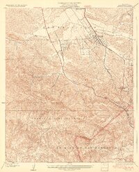
 1933 Chatsworth1933 Print · USGSThe Chatsworth area in the early thirties shows a unique blend of old ranching estates and new valley subdivisions. You can trace early property lines at Rancho Sombra del Roble or locate historic landmarks like the Garden of The Gods and Oakwood Cemetery.
 - 1933 Map of Newhall
 1933 Newhall1933 Print · USGSNewhall and the northern Santa Susana Mountains are shown in the early thirties as vital transit corridors for rail and road. Researchers can trace the path of the Southern Pacific through the Tunnel or locate the Dept of Commerce Landing Field.4 unique versions available
End of results
Showing maps 1-3 of 3
Top cities near Unincorporated Chatsworth
- Los Angeles historical maps
- Santa Clarita historical maps
- Thousand Oaks historical maps
- Simi Valley historical maps
- Burbank historical maps
- Beverly Hills historical maps
See more
Top neighborhoods of Unincorporated Chatsworth
- Deer Lake Highlands historical maps
- Twin Lakes historical maps
- La Quinta historical maps
- Fern Ann Falls historical maps
- Deerlake Ranch historical maps
Frequently asked questions
- What are the different types of historical maps available for Unincorporated Chatsworth?
- What is the oldest map of Unincorporated Chatsworth?
- Where can I purchase historical maps of Unincorporated Chatsworth for my home or office?
- Where can I download high-res historical maps of Unincorporated Chatsworth?
- Are there historical topographic maps available for Unincorporated Chatsworth?
- Is there historical aerial imagery available for Unincorporated Chatsworth?
- Where are historical maps of Unincorporated Chatsworth sourced from?