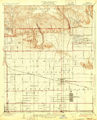
1932 Map of Zelzah
USGS Topo · Published 1932About this map
The northern reaches of the San Fernando Valley meet the rising slopes of the Santa Susana Mountains in this early 1930s landscape. This area, largely defined by the agricultural expansion of the Ex Mission San Fernando, shows a transition from the rugged drainage of Browns Canyon and Limekiln Canyon to the emerging residential and commercial grids. A distinct economic driver of the era is visible in the specialized agricultural settlements, specifically the Weeks Poultry Colony and Runnymede Poultry Colony, which illustrate the region's intensive poultry farming industry prior to mid-century urbanization.
Find a feature on this map
42 named features on this map. Tap any name to fly to it.
Don’t see what you’re looking for? This feature index may not catch every label — zoom into the map to look around manually.
Map Details
Editions of this 1932 Zelzah Map
This is the sole edition of this map. No revisions or reprints were ever made.
Other maps of this area

1894 · Los Angeles
USGS Topo · 1:62,500

1896 · Santa Monica
USGS Topo · 1:62,500

1898 · Santa Monica
USGS Topo · 1:62,500

1900 · Los Angeles
USGS Topo · 1:62,500

1900 · Fernando
USGS Topo · 1:62,500

1901 · Southern California Sheet No. 1
USGS Topo · 1:250,000

1902 · Santa Monica
USGS Topo · 1:62,500

1903 · Calabasas
USGS Topo · 1:62,500

1903 · Camulos
USGS Topo · 1:125,000

1903 · Santa Susana
USGS Topo · 1:62,500
Featured Places
- Los Angeles, CA
- Deer Lake Highlands, Unincorporated Chatsworth
- Unincorporated Chatsworth, CA
- Los Angeles County, CA
- United States