Old Maps of Vernon, California for Academic Research
Study the evolution of Vernon with 45 high-resolution historic maps. Whether you're teaching, researching, or modeling changes in land use, these maps provide essential visual documentation of urban, environmental, and geographic change.
- Analyze long-term change: Track patterns in development, transportation, and natural features.
- Ideal for environmental or urban studies: Support academic projects with primary historical map data.
- Use in the classroom or lab: Educators and researchers rely on these maps to bring historical context to life.
These maps are a powerful tool for teaching, research, and visualizing how Vernon has changed over the decades.
Vernon, CA maps
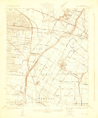
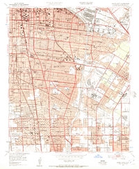
(45)- 1894 Map of Los Angeles
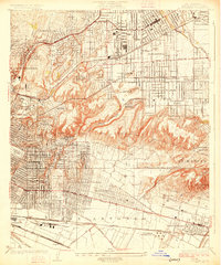
 1894 Los Angeles1894 Print · USGSLos Angeles was a growing rail hub at the end of the nineteenth century, balancing its agricultural heritage with new mountain resorts. Researchers can trace early neighborhoods like Boyle Heights, find the National Soldiers Home, or follow the Mt. Lowe Hotel incline.
 - 1896 Map of Pasadena
 1896 Pasadena1896 Print · USGSGreater Los Angeles was a network of rail-connected resort towns and historic missions in the late nineteenth century. You can trace early transit lines to the Raymond Hotel, locate the original Mission site, and find vanished stops like Las Casetas Sta.2 unique versions available
 - 1896 Map of Downey
 1896 Downey1896 Print · USGSThe Los Angeles Basin was a landscape of vast ranchos and emerging rail towns in the 1890s. Genealogists and historians can trace the early footprints of Downey and Whittier, alongside unique landmarks like the Poor Farm Sta. and Fulton Wells.
 - 1899 Map of Downey
 1899 Downey1899 Print · USGSCoastal Los Angeles County at the close of the nineteenth century reveals a landscape of massive ranchos being carved into early townships. Genealogists can trace family roots through historic rail stops like Obed Bell Sta. and vanished settlements like Spanishtown or Nadeau Park.
 - 1900 Map of Pasadena
 1900 Pasadena1900 Print · USGSThe San Gabriel Valley is captured here at a pivotal moment of expansion just as the rail networks reached the foothills. Researchers can trace the layout of early Pasadena and Monrovia, locate the Echo Mountain Mt. Lowe Hotel, or find the historic Mission and Raymond Hotel.10 unique versions available
 - 1900 Map of Los Angeles
 1900 Los Angeles1900 Print · USGSGreater Los Angeles was a mosaic of expansive ranchos and emerging rail towns at the turn of the century. You can trace the early footprints of Hollywood, locate the historic Soldiers Home, and follow the mountain rails to the Echo Mountain Mt. Lowe Hotel.4 unique versions available
 - 1901 Map of Southern California Sheet No. 1
 1901 Southern California Sheet No. 11901 Print · USGSGreater Los Angeles at the dawn of the twentieth century is a landscape of growing citrus towns and a burgeoning rail network. Genealogists and historians can trace the early gridded streets of Hollywood and Pasadena or locate landmarks like Bear Lake and the Cahuilla Indian Reservation.6 unique versions available
 - 1902 Map of Downey
 1902 Downey1902 Print · USGSThe Los Angeles coastal plain at the turn of the century shows a network of early citrus towns and Spanish rancho boundaries. Trace the development of the river system and rail stops like Poor Farm Sta., Fulton Wells, and the growing community of Whittier.9 unique versions available
 - 1904 Map of Southern California Sheet No. 1, 1905 Print
 1904 Southern California Sheet No. 11905 Print · USGSSouthern California at the dawn of the twentieth century shows a landscape of citrus groves and coastal towns connected by rail. Genealogists and historians can trace early settlements like San Juan Capistrano, find remote sites like the Rose Mine, and study the original water systems of the Santa Ana River.2 unique versions available
 - 1923 Map of Bell
 1923 Bell1923 Print · USGSLos Angeles County was rapidly urbanizing in the early twenties as residential tracts replaced citrus groves and ranchlands. Genealogists can trace family footprints through the numerous local schools like Old River School or find historical industrial sites such as the Rio Grande Oil Co.
 - 1923 Map of Watts
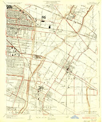
 1923 Watts1923 Print · USGSSouth-central Los Angeles is seen here during its mid-twenties transition into a major metropolitan corridor. Researchers can trace early street grids and rail lines through the City of Watts, Lynwood, and schools like Willowbrook School.
 - 1924 Map of Alhambra
 1924 Alhambra1924 Print · USGSThe Los Angeles basin is captured here during the mid-twenties as streetcar suburbs and oil derricks began to reshape the landscape. Genealogists and researchers can trace early neighborhoods like Belvidere Gardens or locate family sites near Evergreen Cem and Granada School.
 - 1924 Map of Watts
 1924 Watts1924 Print · USGSSouth Los Angeles and its neighboring industrial suburbs come to life in the mid-1920s as a burgeoning network of rail lines and residential grids. Researchers can trace early school sites like Willowbrook School and large-scale industrial landmarks including the Goodyear Rubber Co.2 unique versions available
 - 1925 Map of Bell
 1925 Bell1925 Print · USGSSoutheast Los Angeles during the mid-twenties shows a landscape of growing towns and industrial expansion between the river forks. Genealogists and researchers can trace early neighborhoods in Bell and Maywood or locate landmarks like the County Farm Hondo PO and Rio Grande Oil Refinery.2 unique versions available
 - 1926 Map of Alhambra
 1926 Alhambra1926 Print · USGSAlhambra and its neighboring suburbs in the mid-twenties show a landscape transitioning from rural ranchos to dense residential grids. Genealogists and historians can trace family locations near San Gabriel Mission, Evergreen Cemetery, and early schools like Granada School.4 unique versions available
 - 1928 Map of Los Angeles
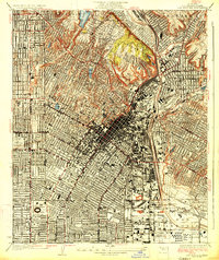 1928 Los Angeles1928 Print · USGSLos Angeles in the late twenties shows a booming cityscape of streetcars and rising institutions before the modern freeway era. Researchers can trace the early footprints of the Ambassador Hotel, Rosedale Cemetery, and the Pacific Electric rail lines.2 unique versions available
 - 1936 Map of Bell
 1936 Bell1936 Print · USGSThe industrial heart of Los Angeles County is captured here in the mid-1930s as rail-side communities like Bell and Lynwood expand. Trace the early footprints of the Rio Grande Oil Refinery, locate the County Farm Hondo PO, or find family roots near Gallatin Sch.
 - 1937 Map of Watts
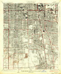 1937 Watts1937 Print · USGSLos Angeles and its southern neighbors show a landscape of rapid industrial and rail expansion in the mid-1930s. Researchers can trace the early residential street grids and commercial hubs surrounding the General Petroleum Tank Farm, Watts, and the Pacific Electric lines.2 unique versions available
 - 1942 Map of Downey
 1942 Downey1942 Print · USGSThe Los Angeles Basin and North Orange County appear here during the wartime boom, showcasing a landscape transitioning from ranchos to suburbs. Trace the historic Pacific Electric rail lines, the oil fields of Santa Fe Springs, and early settlements like Hynes and Studebaker.
 - 1943 Map of San Pedro
 1943 San Pedro1943 Print · USGSThe South Bay and Los Angeles Harbor area appear here during the Second World War, showing a landscape of burgeoning industry and aviation. Trace wartime infrastructure and local landmarks like Hughes Airport, Terminal Island, and Inglewood Park Cem.
 - 1943 Map of Downey, 1963 Print
 1943 Downey1963 Print · USGSSoutheast Los Angeles County and northern Orange County appear here at the height of the mid-century boom. Researchers can trace the massive rail infrastructure of the Pacific Electric and locate landmarks like the County Hospital and Signal Hill.2 unique versions available
 - 1949 Map of Los Angeles
 1949 Los Angeles1949 Print · USGSSouthern California and the South Coast appear at the onset of the post-war boom, from the Channel Islands to the Mojave Desert. Trace early aviation sites like Lockheed Air Terminal and mining history at the Redrock Quicksilver Mine and Redrover Mine.2 unique versions available
 - 1949 Map of Long Beach
 1949 Long Beach1949 Print · USGSSouthern California at the start of the post-war boom shows the rapid development of the Los Angeles basin and the South Bay. Genealogists and historians can trace the evolution of early suburbs like Gardena and Lynwood or the coastal defenses at Ft MacArthur Lower Reservation.2 unique versions available
 - 1949 Map of South Gate, 1957 Print
 1949 South Gate1957 Print · USGSSoutheast Los Angeles at the end of the 1940s reveals a thriving hub of rail, aviation, and industry during its post-war growth spurt. Genealogists and historians can trace family-named sites like Rancho Los Amigos and the Russian Molokan Cem alongside defunct airfields like Vail Airport.2 unique versions available
 - 1952 Map of South gate
 1952 South gate1952 Print · USGSSoutheast Los Angeles is shown in the early fifties as the industrial heart of the region, where a complex network of rail and river corridors fueled rapid growth. Researchers can trace family roots at the Russian Molokan Cem or find local landmarks like St Mathias Sch and Mission Hosp.
Showing maps 1-25 of 45
Top cities near Vernon
- Los Angeles historical maps
- Long Beach historical maps
- Anaheim historical maps
- Glendale historical maps
- Garden Grove historical maps
- Torrance historical maps
See more
Frequently asked questions
- What are the different types of historical maps available for Vernon?
- What is the oldest map of Vernon?
- Where can I purchase historical maps of Vernon for my home or office?
- Where can I download high-res historical maps of Vernon?
- Are there historical topographic maps available for Vernon?
- Is there historical aerial imagery available for Vernon?
- Where are historical maps of Vernon sourced from?