1950s Maps of Sacramento Landing, California
Explore 3 historic maps of Sacramento Landing from the 1950s. These maps offer a rare glimpse into what life looked like during the 1950s — showing old roads, neighborhoods, homes, and landmarks that have changed or disappeared over time.
Whether you're researching your family's past, planning a metal detecting trip, or studying how Sacramento Landing's landscape evolved across the 1950s, these high-resolution maps are a powerful tool for exploring the history of this region.
- Focus on a specific era: All maps on this page are from the 1950s, giving you a focused view of this time period.
- See what’s changed: Compare century-old streets, trails, and buildings to today's modern landscape using overlays and satellite layers.
- Research with precision: Use these maps for genealogy, historical research, land use analysis, or educational projects.
- View, download, or print: Maps are fully viewable online in high resolution, and can be downloaded or printed for your own records.
Start exploring Sacramento Landing's history through authentic maps from the 1950s. This is your window into the past.
Sacramento Landing, CA maps
(3)- 1954 Map of Tomales, 1955 Print
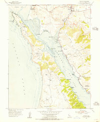 1954 Tomales1955 Print · USGSCoastal Marin County in the early fifties reveals a landscape of dairy ranches and tidal estuaries before significant modern development. Genealogists and historians can trace family properties like Kehoe Ranch, find the Joint Union High Sch, and follow the Old Railroad Grade along the bay.6 unique versions available
 - 1954 Map of Point Reyes, 1959 Print
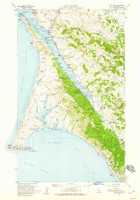 1954 Point Reyes1959 Print · USGSCoastal Marin County in the mid-fifties is a landscape of sprawling dairy ranches and tidal inlets before it became a national park. Genealogists can trace family holdings like Upper Pierce Ranch and Laguna Ranch or find sites like the Olema Cam and Marshall Sch.5 unique versions available
 - 1958 Map of Santa Rosa, 1968 Print
 1958 Santa Rosa1968 Print · USGSThe North Bay and Wine Country are captured in the mid-twentieth century as the region balanced its agricultural roots with a growing military and recreational footprint. Researchers can trace the Northwestern Pacific RR through the Russian River valley or locate landmarks like the Petaluma Adobe Historical Monument and The Geysers Resort.3 unique versions available
End of results
Showing maps 1-3 of 3
Top cities near Sacramento Landing
- San Francisco historical maps
- Santa Rosa historical maps
- Petaluma historical maps
- Rohnert Park historical maps
- Cotati historical maps
Frequently asked questions
- What are the different types of historical maps available for Sacramento Landing?
- What is the oldest map of Sacramento Landing?
- Where can I purchase historical maps of Sacramento Landing for my home or office?
- Where can I download high-res historical maps of Sacramento Landing?
- Are there historical topographic maps available for Sacramento Landing?
- Is there historical aerial imagery available for Sacramento Landing?
- Where are historical maps of Sacramento Landing sourced from?