1940s Maps of Bagby, California
Explore 4 historic maps of Bagby from the 1940s. These maps offer a rare glimpse into what life looked like during the 1940s — showing old roads, neighborhoods, homes, and landmarks that have changed or disappeared over time.
Whether you're researching your family's past, planning a metal detecting trip, or studying how Bagby's landscape evolved across the 1940s, these high-resolution maps are a powerful tool for exploring the history of this region.
- Focus on a specific era: All maps on this page are from the 1940s, giving you a focused view of this time period.
- See what’s changed: Compare century-old streets, trails, and buildings to today's modern landscape using overlays and satellite layers.
- Research with precision: Use these maps for genealogy, historical research, land use analysis, or educational projects.
- View, download, or print: Maps are fully viewable online in high resolution, and can be downloaded or printed for your own records.
Start exploring Bagby's history through authentic maps from the 1940s. This is your window into the past.
Bagby, CA maps
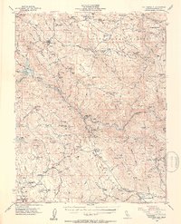
(4)- 1947 Map of San Jose, 1948 Print
 1947 San Jose1948 Print · USGSNorthern California's heartland is captured here just after the war, showing the rapid growth of the Santa Clara and Central Valleys. Researchers can trace the legacy of rail and water at Castle Air Force Base, Stockton, and the Hetch Hetchy Aqueduct.
 - 1947 Map of Coulterville, 1953 Print
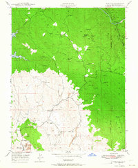
 1947 Coulterville1953 Print · USGSIn the late 1940s, this portion of the Mother Lode still shows a landscape dense with gold mining and ranching activity. Researchers can trace the heritage of Coulterville and Hornitos or locate numerous historic workings like the Mary Harrison Mine and Red Cloud Mines.4 unique versions available
 - 1947 Map of Hornitos, 1964 Print
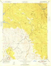
 1947 Hornitos1964 Print · USGSMariposa County gold country is mapped here just after the war, showing the industrial footprint of the local mining district. Genealogists can locate old family sites like Williams Ranch or trace the legacy of the Mt Gaines Mine and Quartzburg Sch.3 unique versions available
 - 1949 Map of Hornitos
 1949 Hornitos1949 Print · USGSMariposa County in the late 1940s remained a landscape defined by its mining heritage and cattle ranching. Researchers can trace historic claims from the Yellowstone Mine to the Red Cloud Mines, and locate the site of the old Quartzburg Sch near Hornitos.
End of results
Showing maps 1-4 of 4
Frequently asked questions
- What are the different types of historical maps available for Bagby?
- What is the oldest map of Bagby?
- Where can I purchase historical maps of Bagby for my home or office?
- Where can I download high-res historical maps of Bagby?
- Are there historical topographic maps available for Bagby?
- Is there historical aerial imagery available for Bagby?
- Where are historical maps of Bagby sourced from?