Old Maps of Mariposa County, California
Explore 326 old maps of Mariposa County, spanning from 1893 to today. These high-resolution historic maps reveal how streets, neighborhoods, landmarks, and natural features evolved over time — perfect for genealogy, metal detecting, research, and local history exploration.
What you can do with these maps:
- See how Mariposa County changed over time: Compare historical maps to modern-day views to trace roads, homesites, rail lines & more.
- View detailed metadata: Each map includes creators, publishers, year, scale, and archive source.
- Overlay maps with satellite & LiDAR: Visualize the past alongside modern tools to explore terrain & human change.
- Trusted historical sources: Maps sourced from the USGS, Library of Congress, and other archives.
- Access maps your way: View online, download high-res files, or order prints for personal or research use.
Start exploring old maps of Mariposa County to uncover forgotten places, hidden landmarks, and the deep history beneath your feet.
Mariposa County, CA maps
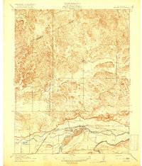
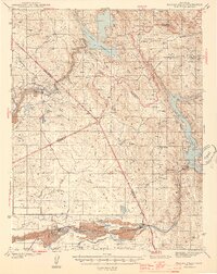
(326)- 1893 Map of Sonora
 1893 Sonora1893 Print · USGSThe Mother Lode region comes alive in the early 1890s, showing a landscape defined by mining camps and early river crossings before the big dams. Genealogists and historians can trace old settlements like Chinese Camp and Big Oak Flat, or locate industrial sites like the Olsen Mine and Hobron Mill.
 - 1896 Map of Sonora
 1896 Sonora1896 Print · USGSThe Mother Lode gold country is shown in the late nineteenth century as mining towns and river crossings defined the Sierra Nevada foothills. Genealogists and researchers can trace early routes through Chinese Camp and Coulterville, or locate industrial sites like the Red Cloud Mine and Benton Mill.
 - 1897 Map of Sonora
 1897 Sonora1897 Print · USGSThe Mother Lode region at the close of the nineteenth century is revealed here through its gold-country towns and rugged mining infrastructure. Trace the early footprints of Sonora, Coulterville, and Hornitos alongside sites like the Red Cloud Mine and Ward Ferry.8 unique versions available
 - 1897 Map of Yosemite
 1897 Yosemite1897 Print · USGSThe Sierra Nevada high country is captured here during the earliest years of the national park, before major infrastructure changed the landscape. Researchers can locate early homesteads and travel stops like Hog Ranch, Harden Ranch, and Sequoia.
 - 1898 Map of Sonora, 1932 Print
 1898 Sonora1932 Print · USGSThe Mother Lode region at the close of the nineteenth century reveals a complex world of river dams and mining camps. Genealogists can trace family names at Chinese Camp or Soulsbyville and locate early industry at the Red Cloud Mine and Bandarita Mine.
 - 1900 Map of Yosemite
 1900 Yosemite1900 Print · USGSThe central Sierra Nevada appears here in the late nineteenth century, prior to the major damming projects that reshaped the river valleys. Genealogists and historians can trace pioneer outposts like Harden Ranch and Hite Cove, or the early tourism hub at Yosemite.
 - 1901 Map of Mt. Lyell
 1901 Mt. Lyell1901 Print · USGSThe High Sierra at the end of the century is captured here in immense detail, showing the early boundaries of Yosemite National Park. Researchers can trace old mountain routes past Soda Springs, Tuolumne Meadows, and Miller Bridge.12 unique versions available
 - 1903 Map of Yosemite
 1903 Yosemite1903 Print · USGSThe High Sierra and foothills of Mariposa County appear here in the early 1900s, documenting the early ranching and travel networks of the region. Local historians and genealogists can trace family holdings at Harden Ranch, the mining hub of Hite Cove, and the isolated Stage Station.2 unique versions available
 - 1909 Map of Yosemite
 1909 Yosemite1909 Print · USGSMariposa and Tuolumne counties are shown here at the turn of the century, prior to the damming of the Tuolumne River. Researchers can trace early ranching and mining sites like Hog Ranch, Hite Cove, and the historic Stage Station.7 unique versions available
 - 1912 Map of Mariposa
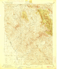
 1912 Mariposa1912 Print · USGSThe California Sierra foothills in the early twentieth century are mapped here as a hive of mining and timber activity. Researchers can trace the legacy of remote settlements and family lands including Grub Gulch, the Indian Settlement, and Knowles.6 unique versions available
 - 1915 Map of Owens Creek
 1915 Owens Creek1915 Print · USGSThe foothills of the central valley come alive in the mid-1910s as this survey traces the critical water and road networks of the era. Researchers can follow the historic path of the Old Miller and Stockton Road or trace the winding courses of Owens Creek and Mariposa Creek.2 unique versions available
 - 1915 Map of La Grange, 1957 Print
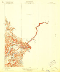
 1915 La Grange1957 Print · USGSThe foothills of the Sierra Nevada meet the valley floor in the early 1900s, centered on the vital waterworks of the Tuolumne River. Researchers can trace the early infrastructure of La Grange Dam and find family-history landmarks like the Live Oak School and Basso Bridge.
 - 1916 Map of Merced Falls, 1957 Print
 1916 Merced Falls1957 Print · USGSThe riverfront settlement of Merced Falls is captured here in the early twentieth century as a bustling industrial and transit hub. Researchers can trace the legacy of mining through the Tailings along the Merced River and follow historic routes like Old Mill Road.
 - 1918 Map of Snelling
 1918 Snelling1918 Print · USGSCentral California's river-driven economy is on display in this early twentieth-century survey of the Merced River valley. Researchers can trace historic irrigation routes like the Crocker Canal and locate the Anderson School or the town of Snelling.3 unique versions available
 - 1918 Map of Owens Creek
 1918 Owens Creek1918 Print · USGSThe foothills of the Sierra Nevada transition into the valley floor during the early twentieth century along the Mariposa Co Merced Co boundary. Local historians can trace the path of the Old Ft. Miller and Stockton Road and the early reaches of Owens Creek.2 unique versions available
 - 1918 Map of La Grand
 1918 La Grand1918 Print · USGSAgricultural life in the San Joaquin Valley comes into focus just before the 1920s, dominated by the railroad and a network of Sierra-fed creeks. You can trace the early rail stops at Dickinson and Marguerite or locate rural landmarks like Appling School and the Chowchilla River.
 - 1919 Map of Indian Gulch
 1919 Indian Gulch1919 Print · USGSMariposa County mining and ranching life are captured here during the mid-1910s, showing a rugged landscape transitioning from frontier camps to established districts. Researchers can locate remote operations like the Pocahontas Mine and early rural education sites like White Rock School.
 - 1919 Map of Haystack Mountain
 1919 Haystack Mountain1919 Print · USGSThe rural borderlands of Merced and Mariposa counties are captured here just after the First World War. Researchers can trace the path of the Merced Falls and Hornitos Road and locate specific water sources like Upper Well and Lower Well.
 - 1919 Map of La Grange
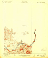
 1919 La Grange1919 Print · USGSThe foothills of the Sierra Nevada come into focus during the early years of California's water-rights expansion. Trace the historical footprint of La Grange and local landmarks like the Live Oak School, the La Grange Dam, and Dawson Lake.3 unique versions available
 - 1919 Map of Merced Falls
 1919 Merced Falls1919 Print · USGSThe foothills of the Sierra Nevada meet the valley floor in the years following the gold rush, centered on the industrial activity at Merced Falls. Researchers can trace the early dredging era through Tailings along the Merced River and follow historic routes like Old Mill Road.3 unique versions available
 - 1919 Map of Raynor Creek
 1919 Raynor Creek1919 Print · USGSThe foothills of Madera and Merced counties appear here during the early twentieth century, showing a landscape shaped by seasonal waterways and early political borders. Researchers can trace the path of the Chowchilla River and the precise location of the Boundary Line separating Madera Co from its neighbors.
 - 1920 Map of Indian Gulch
 1920 Indian Gulch1920 Print · USGSMariposa County at the height of its early mining and ranching era is captured in this meticulous 1920s-era topographic survey. Researchers can trace family history at the Hornitos School or locate historic claims like the Ruth Pierce Mine and Johnnie Green Mine.3 unique versions available
 - 1942 Map of Raymond
 1942 Raymond1942 Print · USGSMadera County ranching and mining operations are captured here during the early 1940s as the foothills transitioned from wilderness to industry. Researchers can trace the Southern Pacific rail line to Raymond or locate the Daulton Copper Mine and Savage Monument.
 - 1944 Map of Merced Falls
 1944 Merced Falls1944 Print · USGSThe California foothills in the early forties reveal a landscape of active river dredging and massive reservoirs. Trace the historic Coulterville Road through the mines at Solambo Mine Ridge or locate the dredging Tailings near Snelling.2 unique versions available
 - 1944 Map of Raymond
 1944 Raymond1944 Print · USGSMadera County ranching and mining operations are captured in detail during the early 1940s, just as the regional economy transitioned. Genealogists and historians can trace family landmarks like Sixmile House and Bates Station, or locate the Daulton Copper Mine and Union High School.2 unique versions available
Showing maps 1-25 of 326
Frequently asked questions
- What are the different types of historical maps available for Mariposa County?
- What is the oldest map of Mariposa County?
- Where can I purchase historical maps of Mariposa County for my home or office?
- Where can I download high-res historical maps of Mariposa County?
- Are there historical topographic maps available for Mariposa County?
- Is there historical aerial imagery available for Mariposa County?
- Where are historical maps of Mariposa County sourced from?