2020s Maps of Mariposa County, California
Explore 42 historic maps of Mariposa County from the 2020s. These maps offer a rare glimpse into what life looked like during the 2020s — showing old roads, neighborhoods, homes, and landmarks that have changed or disappeared over time.
Whether you're researching your family's past, planning a metal detecting trip, or studying how Mariposa County's landscape evolved across the 2020s, these high-resolution maps are a powerful tool for exploring the history of this region.
- Focus on a specific era: All maps on this page are from the 2020s, giving you a focused view of this time period.
- See what’s changed: Compare century-old streets, trails, and buildings to today's modern landscape using overlays and satellite layers.
- Research with precision: Use these maps for genealogy, historical research, land use analysis, or educational projects.
- View, download, or print: Maps are fully viewable online in high resolution, and can be downloaded or printed for your own records.
Start exploring Mariposa County's history through authentic maps from the 2020s. This is your window into the past.
Mariposa County, CA maps
(42)- 2021 Map of Catheys Valley, 2021 Print
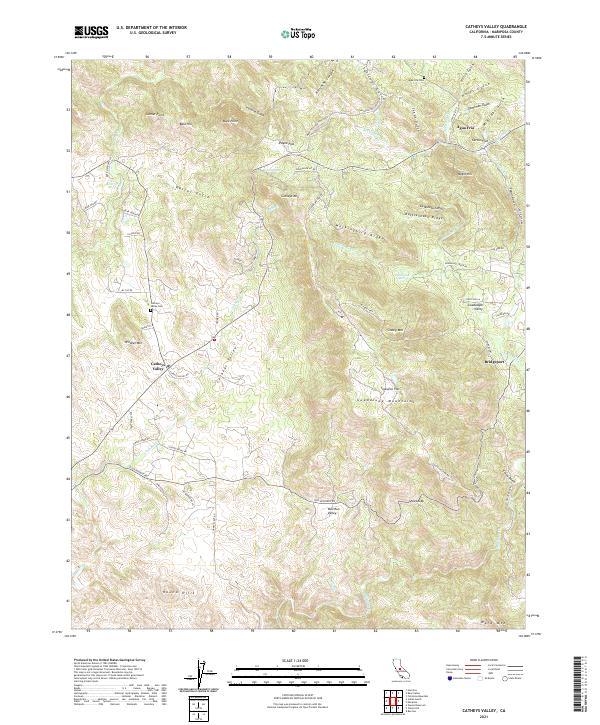 2021 Catheys Valley2021 Print · USGSMariposa County foothills are documented in the early 2020s, showing a landscape of deep gulches and high ridges around Catheys Valley. Researchers can locate historic sites like Agua Fria Cem and the small settlements of Agua Fria and Bridgeport.
 - 2021 Map of Le Grand, 2021 Print
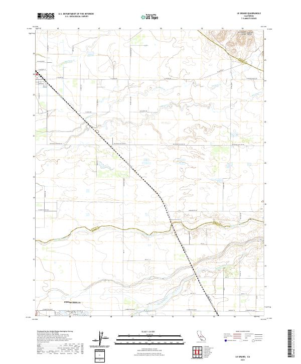 2021 Le Grand2021 Print · USGSMerced and Madera counties meet along the Chowchilla River in this modern survey of the San Joaquin agricultural belt. Genealogists can trace property lines and rural routes like Buchanan Hollow Rd or the northern outskirts of Chowchilla.
 - 2021 Map of Jawbone Ridge, 2021 Print
 2021 Jawbone Ridge2021 Print · USGSTuolumne and Mariposa counties meet in this protected forest landscape during the early twenty-first century. Genealogists and local historians can locate the Dudley Cem near Greeley Hill or trace the early paths to Buck Meadows and China Flat.
 - 2021 Map of Wawona, 2021 Print
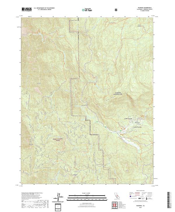 2021 Wawona2021 Print · USGSThe gateway to the high Sierras comes alive in this contemporary survey of the Wawona area and the Merced Wild and Scenic River corridor. Trace the historic Ten Mile Grade or locate the old Greens Mill Site and the heights of Battalion Pass.
 - 2021 Map of Buckingham Mountain, 2021 Print
 2021 Buckingham Mountain2021 Print · USGSThe Mariposa foothills and the Merced River canyon are documented in this recent survey. Local historians can trace old mining and milling sites like the Comet Mine and Standard Mill, or locate family-named landmarks such as Snyder Ridge and Nutmeg Gulch.
 - 2021 Map of Tenaya Lake, 2021 Print
 2021 Tenaya Lake2021 Print · USGSYosemite's high country remains a wilderness of granite domes and alpine lakes in the early twenty-first century. Hikers and historians can trace the paths of the John Muir Trl and Old Tioga Road Trl past landmarks like Clouds Rest and Tenaya Lake.
 - 2021 Map of Raynor Creek, 2021 Print
 2021 Raynor Creek2021 Print · USGSThe northern San Joaquin Valley foothills meet the agricultural plains in this recent survey of the Madera and Mariposa county borders. Researchers can trace the path of the Madera Canal or locate landmarks like Table Mtn and the Chowchilla River.
 - 2021 Map of Haystack Mountain, 2021 Print
 2021 Haystack Mountain2021 Print · USGSThe borderlands of the San Joaquin Valley meet the rising foothills in the early twenty-first century. Researchers can trace historic ranching roads and landmarks like Haystack Mtn, Courthouse Rock, and the seasonal waters of Black Rascal Cr.
 - 2021 Map of Coulterville, 2021 Print
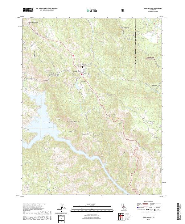 2021 Coulterville2021 Print · USGSMariposa County's rugged Mother Lode country comes into focus in this recent survey of the hills surrounding Coulterville. Local history enthusiasts can trace the old road to Dogtown, locate the Coulterville Chinese Cem, and follow the contours of Lake McClure near Horseshoe Bend.
 - 2021 Map of Snelling, 2021 Print
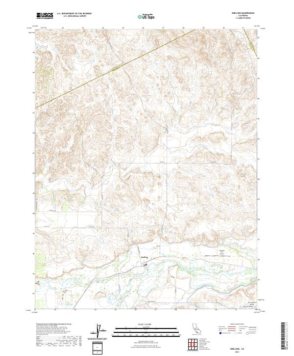 2021 Snelling2021 Print · USGSThe San Joaquin Valley comes into sharp focus in the early 2020s as the Merced River winds south of the historic community of Snelling. Researchers can trace the modern rural road network and identify local landmarks like the Bonanza Hills Airport and Peaslee Cr.
 - 2021 Map of Bear Valley, 2021 Print
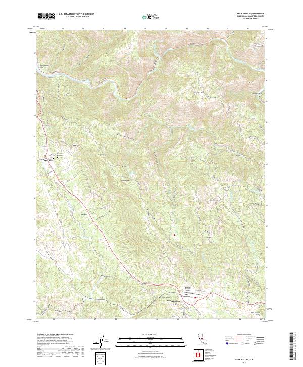 2021 Bear Valley2021 Print · USGSMariposa County’s high country near Bear Valley is shown in detail during the early 2020s, highlighting the area’s rugged mining-era geography. Researchers can trace historic routes like the Old Toll Rd and locate local landmarks such as Bullion Mtn and the Bear Valley IOOF Cem.
 - 2021 Map of Feliciana Mountain, 2021 Print
 2021 Feliciana Mountain2021 Print · USGSMariposa County's foothills are documented in detail here during the early 2020s, from the banks of the Merced Wild and Scenic River to the heights of Feliciana Mtn. Researchers can pinpoint family history sites like Sarah Priest Cem and trace old mining paths along Rumley Mine Rd.
 - 2021 Map of Illinois Hill, 2021 Print
 2021 Illinois Hill2021 Print · USGSMariposa County's high country is captured here in the early twenty-first century, showing a landscape defined by ranching roads and remote peaks. Researchers can locate the White Rock Cem or trace the drainage of Mariposa Cr and Dutchman Cr through the foothills.
 - 2021 Map of Penon Blanco Peak, 2021 Print
 2021 Penon Blanco Peak2021 Print · USGSMariposa and Tuolumne counties meet in this rugged gold country landscape during the early 2020s. Researchers can trace the interface of modern reservoirs like Lake McClure with historic sites such as Whisky Flat, Granite Springs Cem, and old mining roads.
 - 2021 Map of Ben Hur, 2021 Print
 2021 Ben Hur2021 Print · USGSMariposa County, California, is captured here in the early twenty-first century as a landscape of rural roads and remote hillsides. Genealogists and local researchers can trace family roots at Pea Ridge Cem or follow the waters of the Chowchilla River past Buckeye Hill.
 - 2021 Map of Hornitos, 2021 Print
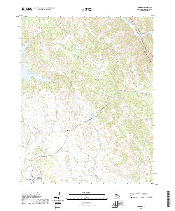 2021 Hornitos2021 Print · USGSMariposa County’s foothills are captured here in the contemporary era, highlighting the persistent footprints of Gold Rush settlements. Genealogists and historians can trace the locations of the Hornitos Odd Fellows Cem, Quartzburg, and Bagby.
 - 2021 Map of Horsecamp Mountain, 2021 Print
 2021 Horsecamp Mountain2021 Print · USGSMadera and Mariposa counties meet in this high-country survey of the Sierra foothills during the early twenty-first century. Researchers can trace historic access routes like Old Wagon Rd and locate landmarks such as Grub Gulch, Specimen Springs, and the Grupe Ranch Airport.
 - 2021 Map of Yosemite Falls, 2021 Print
 2021 Yosemite Falls2021 Print · USGSThe high granite country of the central Sierra Nevada is captured here in the early twenty-first century, spanning the vertical drop from the peaks to the valley floor. Researchers and hikers can trace the complex paths of the Yosemite Falls Trl and Old Tioga Road Trl past landmarks like North Dome and Eagle Peak.
 - 2021 Map of Groveland, 2021 Print
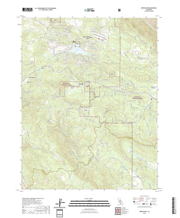 2021 Groveland2021 Print · USGSThe foothills of Tuolumne County appear here in the modern era as a blend of forest lands and residential enclaves. Genealogists and local historians can trace the sites of Second Garrotte, Divide Cem, and the high country of Jackass Ridge.
 - 2021 Map of Mount Lyell, 2021 Print
 2021 Mount Lyell2021 Print · USGSThe High Sierra wilderness comes into focus in this modern survey of the tri-county border area. Mountaineers and historians can trace the high-altitude routes of the Isberg Pass Trl and Post Peak Trl between Mt Maclure and Sadler Lake.
 - 2021 Map of White Chief Mountain, 2021 Print
 2021 White Chief Mountain2021 Print · USGSHigh-altitude wilderness and forest management define this 2021 study of the Madera and Mariposa county line. Researchers can trace the network of trails and meadow systems including Soquel Meadow, the Graveyard Of Giants Trl, and Fresno Dome.
 - 2021 Map of Ten Lakes, 2021 Print
 2021 Ten Lakes2021 Print · USGSThe wilderness of the Sierra Nevada is captured here in the early twenty-first century, centered on the dramatic granite architecture of the Tuolumne drainage. Researchers and hikers can trace the descent through the Grand Canyon of the Tuolumne River and find landmarks like Muir Gorge and Ten Lakes Pass.
 - 2021 Map of Owens Reservoir, 2021 Print
 2021 Owens Reservoir2021 Print · USGSThe Mariposa and Merced county line area comes into focus here during the early 2020s, showing a landscape of rural ranchlands and foothill drainages. Researchers can trace the paths of Bear Creek and Miles Creek or locate the historic Pate Cemetery along the local road network.
 - 2021 Map of Ascension Mountain, 2021 Print
 2021 Ascension Mountain2021 Print · USGSThe Sierra Nevada mountains near the Tuolumne and Mariposa county line are shown here in recent detail. Researchers can trace historic access routes like Old Yosemite Rd and Coulterville Rd near Harden Flat and Crocker Meadow.
 - 2021 Map of Mariposa, 2021 Print
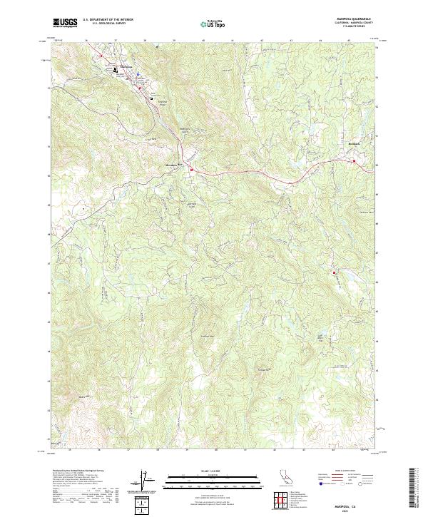 2021 Mariposa2021 Print · USGSMariposa and its surrounding foothill settlements are captured here in the early twenty-first century, showing the enduring layout of the county seat. Researchers can locate early burial sites like Saint Joseph Cem and trace the paths of Agua Fria Cr and Mariposa Cr near Mormon Bar.
Showing maps 1-25 of 42
Frequently asked questions
- What are the different types of historical maps available for Mariposa County?
- What is the oldest map of Mariposa County?
- Where can I purchase historical maps of Mariposa County for my home or office?
- Where can I download high-res historical maps of Mariposa County?
- Are there historical topographic maps available for Mariposa County?
- Is there historical aerial imagery available for Mariposa County?
- Where are historical maps of Mariposa County sourced from?