1960s Maps of Mariposa County, California
Explore 21 historic maps of Mariposa County from the 1960s. These maps offer a rare glimpse into what life looked like during the 1960s — showing old roads, neighborhoods, homes, and landmarks that have changed or disappeared over time.
Whether you're researching your family's past, planning a metal detecting trip, or studying how Mariposa County's landscape evolved across the 1960s, these high-resolution maps are a powerful tool for exploring the history of this region.
- Focus on a specific era: All maps on this page are from the 1960s, giving you a focused view of this time period.
- See what’s changed: Compare century-old streets, trails, and buildings to today's modern landscape using overlays and satellite layers.
- Research with precision: Use these maps for genealogy, historical research, land use analysis, or educational projects.
- View, download, or print: Maps are fully viewable online in high resolution, and can be downloaded or printed for your own records.
Start exploring Mariposa County's history through authentic maps from the 1960s. This is your window into the past.
Mariposa County, CA maps
(21)- 1961 Map of Le Grand, 1962 Print
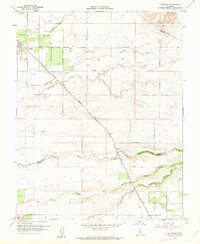 1961 Le Grand1962 Print · USGSThe agricultural plains of Merced and Madera counties are captured here in the early sixties as irrigation transformed the valley. Genealogists and local historians can trace the Atchison Topeka and Santa Fe line through Le Grand and locate family landmarks like Raynor Ranch.2 unique versions available
 - 1961 Map of Raynor Creek, 1963 Print
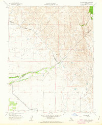 1961 Raynor Creek1963 Print · USGSThe foothills of Madera and Merced counties come into focus in the early sixties as agricultural irrigation reshapes the valley floor. Genealogists and researchers can trace local landmarks like Raynor Ranch Road, Table Mtn, and the Diversion Dam on the Chowchilla River.3 unique versions available
 - 1961 Map of Le Grand, 1963 Print
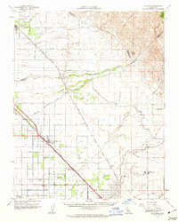 1961 Le Grand1963 Print · USGSMerced and Madera Counties come into focus in the early sixties, showing the vital intersection of the Southern Pacific and Santa Fe rail lines. Genealogists and researchers can locate the Madera Air Force Station, trace the rural Dixieland Sch, and find the exact positions of settlements like Fairmead and Le Grand.
 - 1962 Map of San Jose
 1962 San Jose1962 Print · USGSCentral California in the early sixties showcases the expansion of the San Joaquin and Santa Clara valleys. Researchers can trace the rail-to-road transition along the Southern Pacific RR or locate landmarks like Castle USAF Base and Loma Prieta.4 unique versions available
 - 1962 Map of Haystack Mtn., 1963 Print
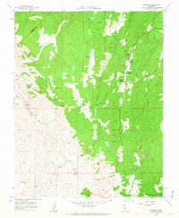
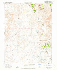 1962 Haystack Mtn.1963 Print · USGSThe Merced and Mariposa county line comes alive in the early sixties, showing a landscape of working ranches and rugged foothill peaks. Researchers can trace historic property boundaries at La Paloma Ranch and find old landmarks like China Hat or the Burns Creek Dam.3 unique versions available
 - 1962 Map of Penon Blanco Peak, 1963 Print
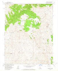
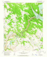
 1962 Penon Blanco Peak1963 Print · USGSMariposa and Tuolumne counties are captured in the early sixties, showing a landscape defined by gold mining history and river canyons. Genealogists and researchers can locate the Granite Spring Cemetery, the Solambo Mine, and the MERCED RIVER RAILROAD GRADE.4 unique versions available
 - 1962 Map of Raymond, 1963 Print
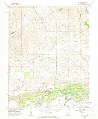
 1962 Raymond1963 Print · USGSMadera County’s granite and gold mining districts are captured here in the early sixties, centered on the rail-linked settlement of Raymond. Researchers can trace the Old Railroad Grade and locate specific industrial sites like the Buchanan Mine and Jesse Belle Shaft.3 unique versions available
 - 1962 Map of Illinois Hill, 1963 Print
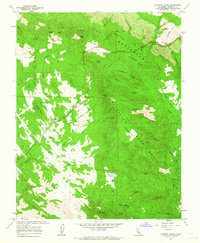
 1962 Illinois Hill1963 Print · USGSMariposa County mining country comes into sharp focus during the early sixties, showing a landscape still tethered to its prospecting past. Researchers can trace the legacy of local claims like the Johnnie Green Mine or locate the White Rock Cemetery and Ganns settlement.3 unique versions available
 - 1962 Map of Snelling, 1963 Print
 1962 Snelling1963 Print · USGSMerced County's river valley shows its industrial and agricultural roots in the early sixties. Genealogists and historians can trace the Merced River gold legacy through Dredge Tailings and locate local landmarks like Snelling-Merced Falls Sch.3 unique versions available
 - 1962 Map of Merced Falls, 1963 Print
 1962 Merced Falls1963 Print · USGSThe foothills of the Sierra Nevada meet the valley floor in the early 1960s, a landscape defined by hydraulic engineering and mining history. Trace the remnants of gold country industry through the Blue Moon Mine, the Old Railroad Grade, and the vast dredge tailings along the Merced River.2 unique versions available
 - 1962 Map of Merced, 1963 Print
 1962 Merced1963 Print · USGSMerced and the surrounding San Joaquin Valley are captured in the early sixties, showing a landscape defined by industrial agriculture and the steel rails of two major railroads. Genealogists and historians can trace family-named properties like La Paloma Ranch or locate local landmarks like Calvary Cem and Planada.
 - 1962 Map of Indian Gulch, 1963 Print
 1962 Indian Gulch1963 Print · USGSMariposa County foothill life is captured in the early sixties, showing a landscape shaped by mining, ranching, and seasonal water. Genealogists can locate family landmarks like the Day Ranch, early burial grounds at Santa Cruz Cem, and the former town at Toledo (Site).
 - 1962 Map of Owens Reservoir, 1963 Print
 1962 Owens Reservoir1963 Print · USGSThe foothills of the Sierra Nevada transition into ranching country in the early 1960s along the Merced and Mariposa border. Researchers can locate early landholdings like Chase Ranch, trace the Dredge Tailings along the creeks, and find the secluded Pate Cem.
 - 1962 Map of La Grange, 1963 Print
 1962 La Grange1963 Print · USGSThe Tuolumne River dominates this Sierra Nevada foothill region during the early sixties as industrial mining and water management reshape the terrain. Researchers can locate gold-era remnants like Fortynine Mine and Mitchell Mine alongside the rising waters of Don Pedro Reservoir.4 unique versions available
 - 1962 Map of Indian Gulch, 1964 Print
 1962 Indian Gulch1964 Print · USGSMariposa County gold country is captured here during the early 1960s, showing a landscape shaped by mining and cattle ranching. Researchers can trace historic family properties and burial grounds like Pate Cem, Savages Trading Post, and the Ruth Pierce Mine.
 - 1962 Map of Raymond, 1964 Print
 1962 Raymond1964 Print · USGSMadera County foothills in the early sixties reveal a landscape of granite quarries and historic ranching outposts. Genealogists and historians can trace family-named sites like Twentytwo Mile House, Adobe Ranch, and the Raymond Cemetery.
 - 1962 Map of Catheys Valley, 1964 Print
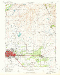
 1962 Catheys Valley1964 Print · USGSMariposa County life in the early sixties centers on the foothill settlement of Catheys Valley and its surrounding ranchlands. Genealogists and historians can trace old homesteads and landmarks like Stonehouse, the Catheys Valley Cemetery, and Savages Trading Post.5 unique versions available
 - 1962 Map of Merced Falls, 1964 Print
 1962 Merced Falls1964 Print · USGSThe California Gold Country during the early sixties reveals a landscape shaped by hydraulic mining and river power. Genealogists and historians can trace family-named sites like McNulty Ridge, locate the Don Pedro Sch, or find the Abbe Mine and Bullion Mill.
 - 1963 Map of Mariposa
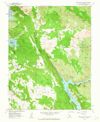
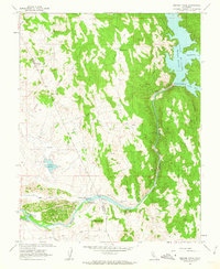
 1963 Mariposa1963 Print · USGSThe High Sierra and Owens Valley meet in the early sixties, showing a landscape defined by gold-rush history and massive post-war water projects. Genealogists and researchers can trace old mining routes near Mariposa, locate the Glacier Point Hotel, and find small settlements like Coarse Gold or Knowles Junction.
 - 1963 Map of Owens Reservoir, 1983 Print
 1963 Owens Reservoir1983 Print · USGSThe border of Mariposa and Merced counties in the early 1960s was a land of managed watersheds and remnant mining operations. Researchers can trace family sites like Chase Ranch, find the Pate Cem, and see the extent of Dredge Tailings along the creek beds.
 - 1966 Map of San Jose
 1966 San Jose1966 Print · USGSCentral California in the mid-1960s reveals a landscape of massive irrigation projects and expanding Cold War military footprints. Researchers can trace the rail-and-river network of the San Joaquin Valley or locate specialized sites like Castle Air Force Base and the Sharp General Depot (Military).
End of results
Showing maps 1-21 of 21
Frequently asked questions
- What are the different types of historical maps available for Mariposa County?
- What is the oldest map of Mariposa County?
- Where can I purchase historical maps of Mariposa County for my home or office?
- Where can I download high-res historical maps of Mariposa County?
- Are there historical topographic maps available for Mariposa County?
- Is there historical aerial imagery available for Mariposa County?
- Where are historical maps of Mariposa County sourced from?