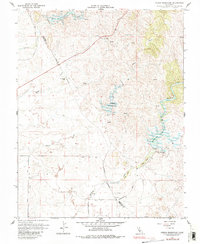
1963 Map of Owens Reservoir
USGS Topo · Published 1983About this map
Pate Cem rests in the central hills of this landscape, a quiet testament to the early families who settled the borderlands between Mariposa and Merced counties. The terrain is defined by a series of north-south drainage systems, most notably Bear Creek, Owens Creek, and Mariposa Creek, each managed by its own impoundment: Bear Reservoir, Owens Reservoir, and Mariposa Reservoir. These waterworks reflect the transition of the region from purely extractive pursuits to managed agricultural and water storage needs during the mid-20th century.
Find a feature on this map
27 named features on this map. Tap any name to fly to it.
Don’t see what you’re looking for? This feature index may not catch every label — zoom into the map to look around manually.
Map Details
Editions of this 1963 Owens Reservoir Map
This is the sole edition of this map. No revisions or reprints were ever made.
Other maps of this area

1915 · Owens Creek
USGS Topo · 1:31,680

1918 · Owens Creek
USGS Topo · 1:31,680

1918 · Planada
USGS Topo · 1:31,680

1918 · La Grand
USGS Topo · 1:31,680

1919 · Indian Gulch
USGS Topo · 1:48,000

1919 · Haystack Mountain
USGS Topo · 1:31,680

1919 · Plainsberg
USGS Topo · 1:31,680

1919 · Raynor Creek
USGS Topo · 1:31,680

1920 · Indian Gulch
USGS Topo · 1:62,500
1942 · Athlone
USGS Topo · 1:62,500