
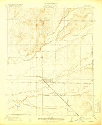
1918 Map of La Grand
USGS Topo · Published 1918About this map
Le Grand serves as the primary hub in this agricultural landscape during the early twentieth century, situated along the diagonal path of the Atchison Topeka and Santa Fe railroad. The terrain is defined by a dense network of seasonal waterways flowing from the foothills toward the valley floor, including Mariposa Creek, Deadman Creek, and the Chowchilla River. These watercourses dictated the local road patterns, such as the Plainsberg and Buchanan Hollow Road, which navigated the low-lying terrain between the creeks. Small rural social centers are visible at the Vineyard School and Appling School, providing essential locations for genealogists tracing family histories in the northern San Joaquin Valley. The map also captures the precise county boundaries between Mariposa, Madera, and Merced, illustrating the political geography of the era as it intersected with the natural flow of Ash Creek and Berenda Slough.
Find a feature on this map
17 named features on this map. Tap any name to fly to it.
Don’t see what you’re looking for? This feature index may not catch every label — zoom into the map to look around manually.
Map Details
Editions of this 1918 La Grand Map
This is the sole edition of this map. No revisions or reprints were ever made.
Other maps of this area

1915 · Owens Creek
USGS Topo · 1:31,680

1916 · Berenda
USGS Topo · 1:31,680

1918 · Owens Creek
USGS Topo · 1:31,680

1918 · Chowchilla
USGS Topo · 1:31,680

1918 · Berenda
USGS Topo · 1:31,680
1918 · Planada
USGS Topo · 1:31,680

1919 · Indian Gulch
USGS Topo · 1:48,000

1919 · Plainsberg
USGS Topo · 1:31,680

1919 · Raynor Creek
USGS Topo · 1:31,680
1920 · Indian Gulch
USGS Topo · 1:62,500