
1919 Map of Raynor Creek
USGS Topo · Published 1919About this map
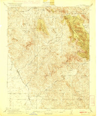
The Chowchilla River winds through this central California landscape at a time when the boundaries between Mariposa, Merced, and Madera counties were still being clearly delineated. This 1919 edition reveals a topography defined by watercourses and political divisions rather than dense settlement. The confluence of several drainage systems, including Deadman Creek, Dutchman Creek, and Raynor Creek, illustrates the complex natural irrigation of the valley and foothills. Land surveyors like E.P. Davis and J.H. LeFeaver captured the area as it transitioned from open range to more formal county jurisdictions, noting the Boundary Line that marked these administrative shifts. The sparse distribution of labels suggests a period of early 20th-century development where the geography was primarily understood through its watersheds and the Mariposa Co Merced Co and Merced Co Madera Co border crossings.
Find a feature on this map
8 named features on this map. Tap any name to fly to it.
Don’t see what you’re looking for? This feature index may not catch every label — zoom into the map to look around manually.
Map Details
Editions of this 1919 Raynor Creek Map
This is the sole edition of this map. No revisions or reprints were ever made.
Other maps of this area

1912 · Mariposa
USGS Topo · 1:125,000

1915 · Owens Creek
USGS Topo · 1:31,680

1916 · Berenda
USGS Topo · 1:31,680

1918 · Owens Creek
USGS Topo · 1:31,680

1918 · Berenda
USGS Topo · 1:31,680

1918 · La Grand
USGS Topo · 1:31,680

1919 · Indian Gulch
USGS Topo · 1:48,000
1920 · Indian Gulch
USGS Topo · 1:62,500

1920 · Kismet
USGS Topo · 1:31,680

1921 · Daulton
USGS Topo · 1:31,680