
1916 Map of Berenda
USGS Topo · Published 1916About this map
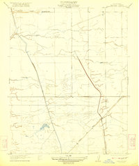
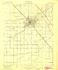
Fairmead and Berenda serve as the primary hubs in this Central Valley landscape during the mid-1910s, defined by a rigid grid of rural roads and competing rail lines. The Southern Pacific tracks run diagonally through the terrain, accompanied by the State Highway (San Francisco New Orleans Line), while the Atchison Topeka and Santa Fe skirts the eastern edge near Sharon. This transportation corridor supported a network of small agricultural outposts and rural institutions, including the Berendo School and Munich School, which provided central gathering points for the surrounding farmsteads. The drainage of the land is visible through the winding course of Berendo Slough in the north and Dry Creek in the south. Smaller named locales like Crumley and Fuller further indicate the era's dense settlement pattern before later consolidation.
Find a feature on this map
14 named features on this map. Tap any name to fly to it.
Don’t see what you’re looking for? This feature index may not catch every label — zoom into the map to look around manually.
Map Details
Editions of this 1916 Berenda Map
This is the sole edition of this map. No revisions or reprints were ever made.
Other maps of this area

1918 · Chowchilla
USGS Topo · 1:31,680

1918 · Berenda
USGS Topo · 1:31,680

1918 · La Grand
USGS Topo · 1:31,680

1919 · Plainsberg
USGS Topo · 1:31,680

1919 · Raynor Creek
USGS Topo · 1:31,680

1920 · Kismet
USGS Topo · 1:31,680

1920 · Bonita Ranch
USGS Topo · 1:31,680

1921 · Bonita Ranch
USGS Topo · 1:31,680
1922 · Kentucky Well
USGS Topo · 1:31,680
1922 · Madera
USGS Topo · 1:31,680