
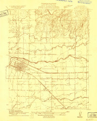
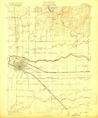
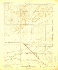
1919 Map of Plainsberg
USGS Topo · Published 1919About this map
Plainsberg serves as a central reference point in this agricultural region of the San Joaquin Valley during the late 1910s. The landscape is defined by an intricate network of waterways, including Mariposa Creek, Deadman Creek, and the branching North, Middle, and South Sloughs, which illustrate the natural drainage patterns before modern extensive water management. The mapping captures the importance of the State Highway and competing rail lines, with the Southern Pacific and the Atchison Topeka and Santa Fe Railroad cutting diagonally across the section lines.
Find a feature on this map
24 named features on this map. Tap any name to fly to it.
Don’t see what you’re looking for? This feature index may not catch every label — zoom into the map to look around manually.
Map Details
Editions of this 1919 Plainsberg Map
This is the sole edition of this map. No revisions or reprints were ever made.
Other maps of this area
1914 · Merced
USGS Topo · 1:31,680

1915 · Owens Creek
USGS Topo · 1:31,680

1916 · Berenda
USGS Topo · 1:31,680
1917 · Merced
USGS Topo · 1:31,680

1918 · Bliss Ranch
USGS Topo · 1:31,680

1918 · Owens Creek
USGS Topo · 1:31,680

1918 · Lingard
USGS Topo · 1:31,680

1918 · Chowchilla
USGS Topo · 1:31,680

1918 · Berenda
USGS Topo · 1:31,680
1918 · Planada
USGS Topo · 1:31,680