
1921 Map of Bonita Ranch
USGS Topo · Published 1921About this map
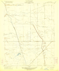
The Fresno River meanders across this Central Valley landscape, defining a network of watercourses and early ranching interests in Madera County. Surveyed by C.A. Stonesifer and Gerald Fitz Gerald in 1919, the map reveals a region transitioning into structured agriculture and livestock management. Named homesteads like the Bonita Ranch and Rattlesnake Ranch serve as primary anchors in an otherwise open terrain of creek beds and surveyed section lines. The presence of Firebaugh Road suggests the established overland routes connecting these ranching outposts to larger regional hubs. The hydrography, featuring Dry Creek in the north and Cottonwood Creek in the south, illustrates the seasonal water patterns that dictated settlement and land use before more intensive irrigation reshaped the Madera area.
Find a feature on this map
8 named features on this map. Tap any name to fly to it.
Don’t see what you’re looking for? This feature index may not catch every label — zoom into the map to look around manually.
Map Details
Editions of this 1921 Bonita Ranch Map
This is the sole edition of this map. No revisions or reprints were ever made.
Other maps of this area

1916 · Berenda
USGS Topo · 1:31,680

1918 · Chowchilla
USGS Topo · 1:31,680

1918 · Berenda
USGS Topo · 1:31,680

1920 · Kismet
USGS Topo · 1:31,680

1920 · Bonita Ranch
USGS Topo · 1:31,680

1921 · Mendota
USGS Topo · 1:31,680
1922 · Kentucky Well
USGS Topo · 1:31,680
1922 · Madera
USGS Topo · 1:31,680
1923 · Biola
USGS Topo · 1:31,680

1924 · Gravelly Ford
USGS Topo · 1:31,680