
1921 Map of Mendota
USGS Topo · Published 1921About this map
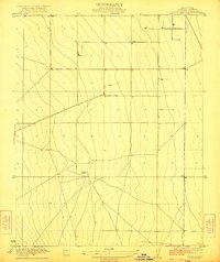
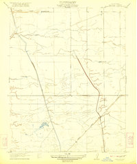
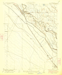
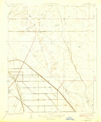
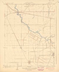
The San Joaquin River and its intricate network of irrigation and drainage channels dominate this San Joaquin Valley landscape in the early 1920s. This survey, conducted shortly after the first World War, illustrates the transformation of the region into an intensive agricultural hub. Key ranching operations such as White House Ranch, Pomona Ranch, and Columbia Ranch are distributed throughout the basin, while the Aliso Canal and Chowchilla Canal demonstrate the sophisticated water management systems required for local industry. Near the southern edge, the settlement of Mendota serves as a central point for these operations. The presence of Aliso Mill and various water bodies like Mowry Lake and Lone Willow Slough highlights the era's reliance on the natural hydrology of the river forks and artificial canals to sustain the burgeoning ranching economy.
Find a feature on this map
17 named features on this map. Tap any name to fly to it.
Don’t see what you’re looking for? This feature index may not catch every label — zoom into the map to look around manually.
Map Details
Editions of this 1921 Mendota Map
This is the sole edition of this map. No revisions or reprints were ever made.
Other maps of this area

1920 · Bonita Ranch
USGS Topo · 1:31,680

1921 · Bonita Ranch
USGS Topo · 1:31,680
1922 · Tufts Ranch
USGS Topo · 1:31,680

1922 · Pozo Farm
USGS Topo · 1:31,680
1922 · Kentucky Well
USGS Topo · 1:31,680
1923 · Firebaugh
USGS Topo · 1:31,680
1924 · Jamesan
USGS Topo · 1:31,680
1924 · Tranquillity
USGS Topo · 1:31,680

1924 · Gravelly Ford
USGS Topo · 1:31,680
1924 · Mendota
USGS Topo · 1:31,680