
1924 Map of Mendota
USGS Topo · Published 1924About this map
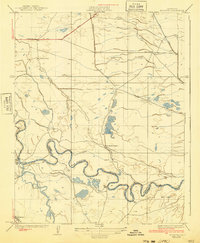
The San Joaquin River winds through the heart of the Central Valley in this 1920s survey, marking the boundary between Madera Co and Fresno Co. The landscape is defined by an intricate network of water management, with the Chowchilla Canal, Aliso Canal, and Mowry Canal diverting water across the flatlands to support large agricultural holdings. Settlements are primarily represented by major estates like Columbia Ranch, Pomona Ranch, and White House Ranch, reflecting an era of large-scale ranching and early irrigation development.
Find a feature on this map
18 named features on this map. Tap any name to fly to it.
Don’t see what you’re looking for? This feature index may not catch every label — zoom into the map to look around manually.
Map Details
Editions of this 1924 Mendota Map
2 editions found
Other maps of this area

1920 · Bonita Ranch
USGS Topo · 1:31,680

1921 · Mendota
USGS Topo · 1:31,680

1921 · Bonita Ranch
USGS Topo · 1:31,680

1922 · Tufts Ranch
USGS Topo · 1:31,680

1922 · Pozo Farm
USGS Topo · 1:31,680

1922 · Kentucky Well
USGS Topo · 1:31,680

1923 · Firebaugh
USGS Topo · 1:31,680

1924 · Jamesan
USGS Topo · 1:31,680

1924 · Tranquillity
USGS Topo · 1:31,680

1924 · Gravelly Ford
USGS Topo · 1:31,680