
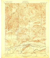
1919 Map of Haystack Mountain
USGS Topo · Published 1919About this map
Merced Falls and Hornitos Road cuts diagonally across this 1919 landscape, serving as a primary transit artery between early Central Valley settlements. The terrain is defined by distinct landmarks such as China Hat and the eponymous Haystack Mtn, which rise above the surrounding drainage networks. The presence of Upper Well and Lower Well suggests the critical importance of managed water sources for cattle or agriculture in this dry environment. Hydrology is further marked by seasonal and permanent waterways including Black Rascal Creek, Burns Creek, and Toledo Creek. A prominent political boundary, the Mariposa Co Merced Co line, traverses the eastern portion of the map, illustrating the intersection of natural topography and administrative borders during this era of California's development.
Find a feature on this map
12 named features on this map. Tap any name to fly to it.
Don’t see what you’re looking for? This feature index may not catch every label — zoom into the map to look around manually.
Map Details
Editions of this 1919 Haystack Mountain Map
This is the sole edition of this map. No revisions or reprints were ever made.
Other maps of this area

1893 · Sonora
USGS Topo · 1:125,000

1896 · Sonora
USGS Topo · 1:125,000

1897 · Sonora
USGS Topo · 1:125,000

1898 · Sonora
USGS Topo · 1:125,000

1914 · Merced
USGS Topo · 1:31,680

1915 · Owens Creek
USGS Topo · 1:31,680

1916 · Hopeton
USGS Topo · 1:31,680

1916 · Merced Falls
USGS Topo · 1:24,000

1917 · Merced
USGS Topo · 1:31,680
1918 · Snelling
USGS Topo · 1:31,680