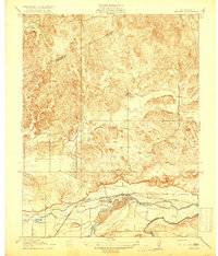
1918 Map of Snelling
USGS Topo · Published 1918About this map
The Merced River serves as the focal point of this 1915 survey, defining the agricultural and hydrographic character of the Central Valley landscape. The settlement of Snelling sits just north of the river, acting as a regional hub near Ingalsbe Slough and the Yosemite road. This era shows a complex irrigation network emerging, with the Crocker Canal and Hoffman Canal diverting water to support the surrounding fields.
Find a feature on this map
17 named features on this map. Tap any name to fly to it.
Don’t see what you’re looking for? This feature index may not catch every label — zoom into the map to look around manually.
Map Details
Editions of this 1918 Snelling Map
3 editions found
Other maps of this area

1893 · Sonora
USGS Topo · 1:125,000

1896 · Sonora
USGS Topo · 1:125,000

1897 · Sonora
USGS Topo · 1:125,000

1898 · Sonora
USGS Topo · 1:125,000

1913 · Dickenson
USGS Topo · 1:31,680

1915 · La Grange
USGS Topo · 1:24,000

1916 · Three Tree Flat
USGS Topo · 1:31,680

1916 · Hopeton
USGS Topo · 1:31,680

1916 · Cooperstown
USGS Topo · 1:31,680

1916 · Merced Falls
USGS Topo · 1:24,000