
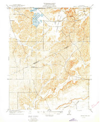
1916 Map of Three Tree Flat
USGS Topo · Published 1916About this map
Water management and rural education define this early 20th-century landscape on the border of Stanislaus Co and Merced Co. The newly established Turlock Reservoir and the extensive Turlock Ditch system reflect the region's transition toward intensive irrigation, transforming the arid terrain of Three Tree Flat. This engineering effort supported a growing population of farming families, evidenced by the distribution of local schoolhouses.
Find a feature on this map
10 named features on this map. Tap any name to fly to it.
Don’t see what you’re looking for? This feature index may not catch every label — zoom into the map to look around manually.
Map Details
Editions of this 1916 Three Tree Flat Map
2 editions found
Other maps of this area

1893 · Sonora
USGS Topo · 1:125,000

1896 · Sonora
USGS Topo · 1:125,000

1897 · Sonora
USGS Topo · 1:125,000

1898 · Sonora
USGS Topo · 1:125,000

1913 · Dickenson
USGS Topo · 1:31,680

1915 · Paulsell
USGS Topo · 1:31,680

1915 · La Grange
USGS Topo · 1:24,000

1916 · Hopeton
USGS Topo · 1:31,680
1916 · Cressey
USGS Topo · 1:31,680

1916 · Montpellier
USGS Topo · 1:31,680