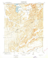
1916 Map of Three Tree Flat
USGS Topo · Published 1916About this map
Tilden School and the more eastern Lafayette School anchor the northern landscape of this California interior quadrangle. Surveyed just before the mid-1910s under the direction of R. B. Marshall, the area is defined by its evolving water management systems. The Turlock Reservoir sits prominent in the northwest, feeding the Turlock Ditch as it winds across the terrain of Three Tree Flat.
Find a feature on this map
12 named features on this map. Tap any name to fly to it.
Don’t see what you’re looking for? This feature index may not catch every label — zoom into the map to look around manually.
Map Details
Editions of this 1916 Three Tree Flat Map
2 editions found
Other maps of this area

1893 · Sonora
USGS Topo · 1:125,000

1896 · Sonora
USGS Topo · 1:125,000

1897 · Sonora
USGS Topo · 1:125,000

1898 · Sonora
USGS Topo · 1:125,000

1913 · Dickenson
USGS Topo · 1:31,680

1915 · Paulsell
USGS Topo · 1:31,680

1915 · La Grange
USGS Topo · 1:24,000

1916 · Three Tree Flat
USGS Topo · 1:31,680

1916 · Hopeton
USGS Topo · 1:31,680

1916 · Cressey
USGS Topo · 1:31,680