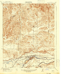
1918 Map of Snelling
USGS Topo · Published 1943About this map
Snelling serves as the focal point of this California Central Valley survey, situated along the northern banks of the Merced River where the valley floor begins its ascent into the foothills. The landscape is defined by its transition from agricultural lowlands to more varied terrain, marked by the courses of Dry Creek and Peaslee Creek. Transport and water management are central to the area's development during the early twentieth century, evidenced by the presence of the Yosemite Valley RR corridor and the intricate irrigation systems including the Hoffman Canal and Crocker Canal. Local life is anchored by small settlements and rural education sites such as Hopeton, Ingalsbe, and the Anderson School. The map captures a moment before modern highway expansion, showing the established path of the Coulterville Road and the distinct Stanislaus and Merced County boundary line.
Find a feature on this map
17 named features on this map. Tap any name to fly to it.
Don’t see what you’re looking for? This feature index may not catch every label — zoom into the map to look around manually.
Map Details
Editions of this 1918 Snelling Map
3 editions found
Other maps of this area

1893 · Sonora
USGS Topo · 1:125,000

1896 · Sonora
USGS Topo · 1:125,000

1897 · Sonora
USGS Topo · 1:125,000

1898 · Sonora
USGS Topo · 1:125,000

1913 · Dickenson
USGS Topo · 1:31,680

1915 · La Grange
USGS Topo · 1:24,000

1916 · Three Tree Flat
USGS Topo · 1:31,680

1916 · Hopeton
USGS Topo · 1:31,680

1916 · Cooperstown
USGS Topo · 1:31,680

1916 · Merced Falls
USGS Topo · 1:24,000