1960s Maps of Cleone, California
Explore 3 historic maps of Cleone from the 1960s. These maps offer a rare glimpse into what life looked like during the 1960s — showing old roads, neighborhoods, homes, and landmarks that have changed or disappeared over time.
Whether you're researching your family's past, planning a metal detecting trip, or studying how Cleone's landscape evolved across the 1960s, these high-resolution maps are a powerful tool for exploring the history of this region.
- Focus on a specific era: All maps on this page are from the 1960s, giving you a focused view of this time period.
- See what’s changed: Compare century-old streets, trails, and buildings to today's modern landscape using overlays and satellite layers.
- Research with precision: Use these maps for genealogy, historical research, land use analysis, or educational projects.
- View, download, or print: Maps are fully viewable online in high resolution, and can be downloaded or printed for your own records.
Start exploring Cleone's history through authentic maps from the 1960s. This is your window into the past.
Cleone, CA maps
(3)- 1960 Map of Ukiah
 1960 Ukiah1960 Print · USGSNorthern California during the late fifties reveals a landscape of deep timber forests and valley agriculture before modern expansion. Trace the historic rail lines of the California Western RR and the Northwestern Pacific RR through settlements like Fort Bragg and Ukiah.2 unique versions available
 - 1960 Map of Fort Bragg, 1962 Print
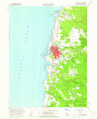 1960 Fort Bragg1962 Print · USGSThe Mendocino coast is shown at a peak of its mid-century industrial and timber era, centered on the bustling hub of Fort Bragg. Researchers can trace the path of the California Western RR or locate coastal landmarks like Lake Cleone and the Noyo waterfront.5 unique versions available
 - 1960 Map of Fort Bragg, 1963 Print
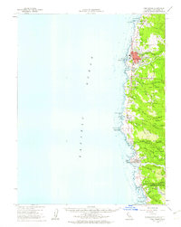 1960 Fort Bragg1963 Print · USGSThe Mendocino coast in the early sixties remains a hub for timber and coastal trade before its full modern tourism expansion. Trace the California Western railroad line or locate historical maritime landmarks like the Point Cabrillo Light Station and Caspar Anchorage.2 unique versions available
End of results
Showing maps 1-3 of 3
Top cities near Cleone
Frequently asked questions
- What are the different types of historical maps available for Cleone?
- What is the oldest map of Cleone?
- Where can I purchase historical maps of Cleone for my home or office?
- Where can I download high-res historical maps of Cleone?
- Are there historical topographic maps available for Cleone?
- Is there historical aerial imagery available for Cleone?
- Where are historical maps of Cleone sourced from?