1920s Maps of Covelo, California
Explore 2 historic maps of Covelo from the 1920s. These maps offer a rare glimpse into what life looked like during the 1920s — showing old roads, neighborhoods, homes, and landmarks that have changed or disappeared over time.
Whether you're researching your family's past, planning a metal detecting trip, or studying how Covelo's landscape evolved across the 1920s, these high-resolution maps are a powerful tool for exploring the history of this region.
- Focus on a specific era: All maps on this page are from the 1920s, giving you a focused view of this time period.
- See what’s changed: Compare century-old streets, trails, and buildings to today's modern landscape using overlays and satellite layers.
- Research with precision: Use these maps for genealogy, historical research, land use analysis, or educational projects.
- View, download, or print: Maps are fully viewable online in high resolution, and can be downloaded or printed for your own records.
Start exploring Covelo's history through authentic maps from the 1920s. This is your window into the past.
Covelo, CA maps
(2)- 1920 Map of Covelo
 1920 Covelo1920 Print · USGSTracing the Eel River in the early twentieth century, this military survey reveals the remote homesteads and rail infrastructure of Mendocino County. Genealogists can locate family-named sites like Fred Simmerly Sr and Nash along the Northwestern Pacific Railroad.
 - 1926 Map of Covelo
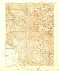 1926 Covelo1926 Print · USGSThe isolated high valley of Covelo is captured here in the mid-1920s, surrounded by the wilderness of the California National Forest. Local historians can locate the Indian School, early ranger outposts, and family landmarks like Browns Ranch.2 unique versions available
End of results
Showing maps 1-2 of 2
Frequently asked questions
- What are the different types of historical maps available for Covelo?
- What is the oldest map of Covelo?
- Where can I purchase historical maps of Covelo for my home or office?
- Where can I download high-res historical maps of Covelo?
- Are there historical topographic maps available for Covelo?
- Is there historical aerial imagery available for Covelo?
- Where are historical maps of Covelo sourced from?